Pueblo Nuevo geodata
Pueblo Nuevo (Falcón) is a seat of a second-order administrative division; located in Venezuela in America/Caracas (GMT-4) time zone. In our database, there are 108 cities with bigger population. Compared to other cities in Venezuela, 100% of cities are located further ↓South; 63.4% of cities are located further →East and 69.7% of cities have higher elevation than Pueblo Nuevo. Note1


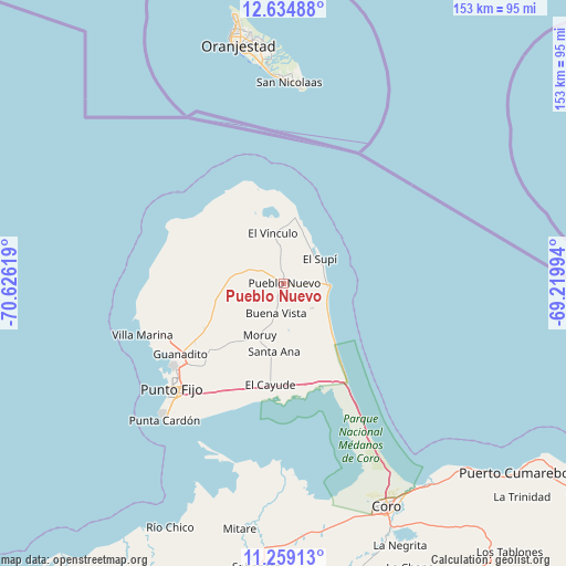
Pueblo Nuevo GPS coordinates[2]
11° 56' 52.368" North, 69° 55' 23.016" West
| Map corner | latitude | longitude |
|---|---|---|
| Upper-left | 12.63488°, | -70.62619° |
| Center: | 11.94788°, | -69.92306° |
| Lower-right: | 11.25913°, | -69.21994° |
| Map W x H: | 153×153 km | = 95.1×95.1mi |
| max Lat: | 11.94788° ⇑0% North |
| Pueblo Nuevo: | 11.94788° |
| min Lat: | ⇓100% South 1.92027° |
| min Long | Pueblo Nuevo | max Long |
| -72.55212° | -69.92306° | -60.99778° |
| W 36.6%⇐ | ⇒63.4% E |
Elevation
Elevation of Pueblo Nuevo is 85 m = 279 ft, and this is 295.6 m = 970 ft below average elevation for this country.
| Max E: |
2986 m = 9797 ft | 69.7% |
| Avg. | 380.6 m = 1249 ft | |
| Pueblo Nuevo | 85 m = 279 ft | |
Min E: |
-4 m = -13 ft | 30.3% |
See also: Venezuela elevation on elevation.city.
Geographical zone
Pueblo Nuevo is located in North Torrid zone (between Equator and Tropic of Cancer). Distance of this Northern Tropic circle is 1277.4 km =793.7 mi to North.| Distance of | km | miles | from Pueblo Nuevo |
|---|---|---|---|
| North Pole | 8678.6 | 5392.6 | to North |
| Arctic Circle | 6072.7 | 3773.4 | to North |
| Tropic Cancer | 1277.4 | 793.7 | to North |
| Equator | 1328.5 | 825.5 | to South |


Nearby cities:
15 places around Pueblo Nuevo: (largest is in red/bold)
• Cabure
95.5 km =59.3 mi,  159°
159°
• Canape Capatárida
114.7 km =71.3 mi,  221°
221°
• Coro
66.3 km =41.2 mi, 155°
• Dabajuro
131.7 km =81.8 mi, 218°
• La Cruz de Taratara
101 km =62.8 mi,  166°
166°
• La Vela de Coro
66.7 km =41.4 mi,  144°
144°
• Pedregal
105.4 km =65.5 mi,  191°
191°
• Puerto Cumarebo
80.5 km =50 mi,  129°
129°
• Punta Cardón
45.3 km =28.1 mi, 224°
• Punto Fijo
41.4 km =25.7 mi,  226°
226°
• Píritu
107.2 km =66.6 mi, 127°
• San Luis
95.6 km =59.4 mi, 164°
• Santa Cruz de los Taques
38.8 km =24.1 mi,  249°
249°
• Tocópero
87.8 km =54.6 mi,  124°
124°
• Urumaco
90.6 km =56.3 mi,  203°
203°
Sources, notices
• [Note1] Compared only with cities in Venezuela existing in our database
• [Src1] Map data: © OpenStreetMap contributors (CC-BY-SA)
• [Src2] Other city data from geonames.org with taken over terms of usage.
• [Src3] Geographical zone / Annual Mean Temperature by Robert A. Rohde @ Wikipedia
