Pedregal geodata
Pedregal (Falcón) is a seat of a second-order administrative division; located in Venezuela in America/Caracas (GMT-4) time zone. In our database, there are 108 cities with bigger population. Compared to other cities in Venezuela, 94.1% of cities are located further ↓South; 66.9% of cities are located further →East and 50.1% of cities have higher elevation than Pedregal. Note1


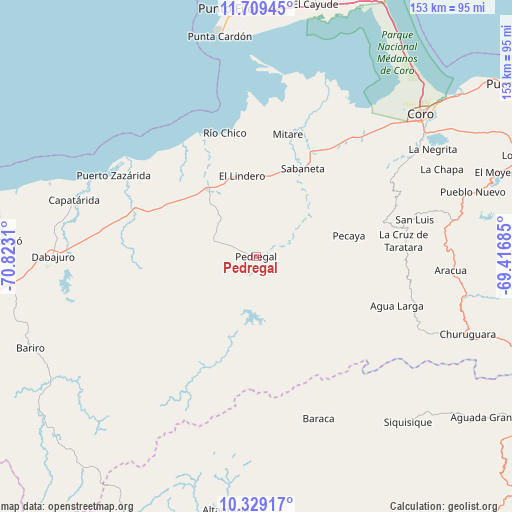
Pedregal GPS coordinates[2]
11° 1' 12.432" North, 70° 7' 11.892" West
| Map corner | latitude | longitude |
|---|---|---|
| Upper-left | 11.70945°, | -70.8231° |
| Center: | 11.02012°, | -70.11997° |
| Lower-right: | 10.32917°, | -69.41685° |
| Map W x H: | 153.5×153.5 km | = 95.4×95.4mi |
| max Lat: | 11.94788° ⇑5.9% North |
| Pedregal: | 11.02012° |
| min Lat: | ⇓94.1% South 1.92027° |
| min Long | Pedregal | max Long |
| -72.55212° | -70.11997° | -60.99778° |
| W 33.1%⇐ | ⇒66.9% E |
Elevation
Elevation of Pedregal is 178 m = 584 ft, and this is 202.6 m = 665 ft below average elevation for this country.
| Max E: |
2986 m = 9797 ft | 50.1% |
| Avg. | 380.6 m = 1249 ft | |
| Pedregal | 178 m = 584 ft | |
Min E: |
-4 m = -13 ft | 49.9% |
See also: Venezuela elevation on elevation.city.
Geographical zone
Pedregal is located in North Torrid zone (between Equator and Tropic of Cancer). Distance of Equator is 1225.3 km =761.4 mi to South.| Distance of | km | miles | from Pedregal |
|---|---|---|---|
| North Pole | 8781.7 | 5456.7 | to North |
| Arctic Circle | 6175.9 | 3837.5 | to North |
| Tropic Cancer | 1380.6 | 857.9 | to North |
| Equator | 1225.3 | 761.4 | to South |


Nearby cities:
15 places around Pedregal: (largest is in red/bold)
• Cabure
57.2 km =35.5 mi,  75°
75°
• Canape Capatárida
57.3 km =35.6 mi,  287°
287°
• Carora
94.3 km =58.6 mi,  177°
177°
• Churuguara
67.7 km =42.1 mi,  109°
109°
• Coro
64.8 km =40.3 mi,  48°
48°
• Dabajuro
60.9 km =37.8 mi,  270°
270°
• La Cruz de Taratara
44.7 km =27.8 mi, 83°
• La Vela de Coro
77.8 km =48.3 mi, 50°
• Punta Cardón
71.7 km =44.6 mi,  351°
351°
• Punto Fijo
75.2 km =46.7 mi, 353°
• San Luis
48.9 km =30.4 mi, 76°
• Santa Cruz de Bucaral
94.7 km =58.8 mi,  103°
103°
• Santa Cruz de los Taques
90.6 km =56.3 mi, 350°
• Siquisique
67.7 km =42.1 mi,  137°
137°
• Urumaco
25 km =15.5 mi,  323°
323°
Sources, notices
• [Note1] Compared only with cities in Venezuela existing in our database
• [Src1] Map data: © OpenStreetMap contributors (CC-BY-SA)
• [Src2] Other city data from geonames.org with taken over terms of usage.
• [Src3] Geographical zone / Annual Mean Temperature by Robert A. Rohde @ Wikipedia
