Punto Fijo geodata
Punto Fijo (Falcón) is a seat of a second-order administrative division; located in Venezuela in America/Caracas (GMT-4) time zone. With population of 131,784 people, there are 32 cities with bigger population in this country. Compared to other cities in Venezuela, 99.5% of cities are located further ↓South; 67.4% of cities are located further →East and 94.4% of cities have higher elevation than Punto Fijo. Note1


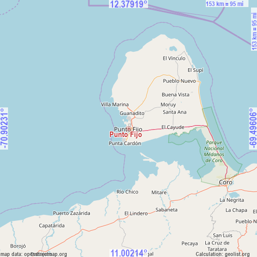
Punto Fijo GPS coordinates[2]
11° 41' 29.472" North, 70° 11' 57.048" West
| Map corner | latitude | longitude |
|---|---|---|
| Upper-left | 12.37919°, | -70.90231° |
| Center: | 11.69152°, | -70.19918° |
| Lower-right: | 11.00214°, | -69.49606° |
| Map W x H: | 153.1×153.1 km | = 95.1×95.1mi |
| max Lat: | 11.94788° ⇑0.5% North |
| Punto Fijo: | 11.69152° |
| min Lat: | ⇓99.5% South 1.92027° |
| min Long | Punto Fijo | max Long |
| -72.55212° | -70.19918° | -60.99778° |
| W 32.6%⇐ | ⇒67.4% E |
Elevation
Elevation of Punto Fijo is 5 m = 16 ft, and this is 375.6 m = 1232 ft below average elevation for this country.
| Max E: |
2986 m = 9797 ft | 94.4% |
| Avg. | 380.6 m = 1249 ft | |
| Punto Fijo | 5 m = 16 ft | |
Min E: |
-4 m = -13 ft | 5.6% |
See also: Punto Fijo elevation on elevation.city.
Geographical zone
Punto Fijo is located in North Torrid zone (between Equator and Tropic of Cancer). Distance of Equator is 1300 km =807.8 mi to South.| Distance of | km | miles | from Punto Fijo |
|---|---|---|---|
| North Pole | 8707.1 | 5410.3 | to North |
| Arctic Circle | 6101.2 | 3791.1 | to North |
| Tropic Cancer | 1305.9 | 811.4 | to North |
| Equator | 1300 | 807.8 | to South |


Nearby cities:
15 places around Punto Fijo: (largest is in red/bold)
• Cabure
88.2 km =54.8 mi,  133°
133°
• Canape Capatárida
73.5 km =45.7 mi,  218°
218°
• Coro
65.6 km =40.8 mi,  119°
119°
• Dabajuro
90.8 km =56.4 mi, 215°
• La Cruz de Taratara
87.7 km =54.5 mi,  142°
142°
• La Vela de Coro
73.6 km =45.7 mi,  110°
110°
• Pedregal
75.2 km =46.7 mi,  173°
173°
• Pueblo Nuevo
41.4 km =25.7 mi,  46°
46°
• Puerto Cumarebo
94.9 km =59 mi,  103°
103°
• Punta Cardón
4.1 km =2.5 mi,  204°
204°
• Píritu
121.1 km =75.2 mi, 107°
• San Luis
84.8 km =52.7 mi, 138°
• Santa Cruz de los Taques
15.9 km =9.9 mi,  337°
337°
• Tocópero
104.6 km =65 mi, 101°
• Urumaco
54.9 km =34.1 mi,  186°
186°
Sources, notices
• [Note1] Compared only with cities in Venezuela existing in our database
• [Src1] Map data: © OpenStreetMap contributors (CC-BY-SA)
• [Src2] Other city data from geonames.org with taken over terms of usage.
• [Src3] Geographical zone / Annual Mean Temperature by Robert A. Rohde @ Wikipedia
