Puerto Cumarebo geodata
Puerto Cumarebo (Falcón) is a seat of a second-order administrative division; located in Venezuela in America/Caracas (GMT-4) time zone. In our database, there are 108 cities with bigger population. Compared to other cities in Venezuela, 98.7% of cities are located further ↓South; 57.3% of cities are located further →East and 88.8% of cities have higher elevation than Puerto Cumarebo. Note1


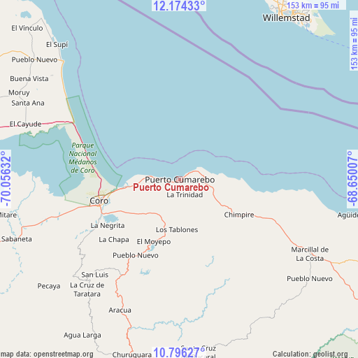
Puerto Cumarebo GPS coordinates[2]
11° 29' 10.104" North, 69° 21' 11.484" West
| Map corner | latitude | longitude |
|---|---|---|
| Upper-left | 12.17433°, | -70.05632° |
| Center: | 11.48614°, | -69.35319° |
| Lower-right: | 10.79627°, | -68.65007° |
| Map W x H: | 153.2×153.2 km | = 95.2×95.2mi |
| max Lat: | 11.94788° ⇑1.3% North |
| Puerto Cumarebo: | 11.48614° |
| min Lat: | ⇓98.7% South 1.92027° |
| min Long | Puerto Cumarebo | max Long |
| -72.55212° | -69.35319° | -60.99778° |
| W 42.7%⇐ | ⇒57.3% E |
Elevation
Elevation of Puerto Cumarebo is 18 m = 59 ft, and this is 362.6 m = 1190 ft below average elevation for this country.
| Max E: |
2986 m = 9797 ft | 88.8% |
| Avg. | 380.6 m = 1249 ft | |
| Puerto Cumarebo | 18 m = 59 ft | |
Min E: |
-4 m = -13 ft | 11.2% |
See also: Venezuela elevation on elevation.city.
Geographical zone
Puerto Cumarebo is located in North Torrid zone (between Equator and Tropic of Cancer). Distance of Equator is 1277.1 km =793.6 mi to South.| Distance of | km | miles | from Puerto Cumarebo |
|---|---|---|---|
| North Pole | 8729.9 | 5424.5 | to North |
| Arctic Circle | 6124 | 3805.3 | to North |
| Tropic Cancer | 1328.8 | 825.7 | to North |
| Equator | 1277.1 | 793.6 | to South |


Nearby cities:
15 places around Puerto Cumarebo: (largest is in red/bold)
• Cabure
47.2 km =29.3 mi,  216°
216°
• Churuguara
77.6 km =48.2 mi,  195°
195°
• Coro
36.1 km =22.4 mi,  255°
255°
• Jacura
71 km =44.1 mi,  130°
130°
• La Cruz de Taratara
61.3 km =38.1 mi, 219°
• La Vela de Coro
23.3 km =14.5 mi, 263°
• Mirimire
77.4 km =48.1 mi,  117°
117°
• Pedregal
98.4 km =61.1 mi,  238°
238°
• Pueblo Nuevo
80.5 km =50 mi,  309°
309°
• Punta Cardón
95.8 km =59.5 mi,  281°
281°
• Punto Fijo
94.9 km =59 mi, 283°
• Píritu
27 km =16.8 mi, 119°
• San Luis
54.4 km =33.8 mi, 221°
• Santa Cruz de Bucaral
74.6 km =46.4 mi,  173°
173°
• Tocópero
10.4 km =6.5 mi,  81°
81°
Sources, notices
• [Note1] Compared only with cities in Venezuela existing in our database
• [Src1] Map data: © OpenStreetMap contributors (CC-BY-SA)
• [Src2] Other city data from geonames.org with taken over terms of usage.
• [Src3] Geographical zone / Annual Mean Temperature by Robert A. Rohde @ Wikipedia
