Puerto La Cruz geodata
Puerto La Cruz (Anzoátegui) is a seat of a second-order administrative division; located in Venezuela in America/Caracas (GMT-4) time zone. With population of 370,000 people, there are 8 cities with bigger population in this country. Compared to other cities in Venezuela, 68.7% of cities are located further ↓South; 84.7% of cities are located further ←West and 82.7% of cities have higher elevation than Puerto La Cruz. Note1


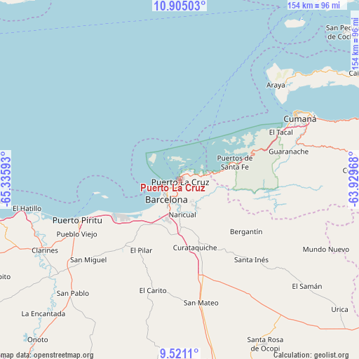
Puerto La Cruz GPS coordinates[2]
10° 12' 49.752" North, 64° 37' 58.08" West
| Map corner | latitude | longitude |
|---|---|---|
| Upper-left | 10.90503°, | -65.33593° |
| Center: | 10.21382°, | -64.6328° |
| Lower-right: | 9.5211°, | -63.92968° |
| Map W x H: | 153.9×153.9 km | = 95.6×95.6mi |
| max Lat: | 11.94788° ⇑31.3% North |
| Puerto La Cruz: | 10.21382° |
| min Lat: | ⇓68.7% South 1.92027° |
| min Long | Puerto La Cruz | max Long |
| -72.55212° | -64.6328° | -60.99778° |
| W 84.7%⇐ | ⇒15.3% E |
Elevation
Elevation of Puerto La Cruz is 40 m = 131 ft, and this is 340.6 m = 1117 ft below average elevation for this country.
| Max E: |
2986 m = 9797 ft | 82.7% |
| Avg. | 380.6 m = 1249 ft | |
| Puerto La Cruz | 40 m = 131 ft | |
Min E: |
-4 m = -13 ft | 17.3% |
See also: Puerto La Cruz elevation on elevation.city.
Geographical zone
Puerto La Cruz is located in North Torrid zone (between Equator and Tropic of Cancer). Distance of Equator is 1135.7 km =705.7 mi to South.| Distance of | km | miles | from Puerto La Cruz |
|---|---|---|---|
| North Pole | 8871.4 | 5512.4 | to North |
| Arctic Circle | 6265.5 | 3893.2 | to North |
| Tropic Cancer | 1470.2 | 913.5 | to North |
| Equator | 1135.7 | 705.7 | to South |


Nearby cities:
15 places around Puerto La Cruz: (largest is in red/bold)
• Anaco
89.1 km =55.4 mi,  168°
168°
• Aragua de Barcelona
87 km =54.1 mi,  194°
194°
• Araya
58 km =36 mi,  45°
45°
• Barcelona
10.4 km =6.5 mi,  214°
214°
• Boca de Uchire
86.9 km =54 mi,  263°
263°
• Clarines
65.8 km =40.9 mi,  242°
242°
• Cumanacoa
78.2 km =48.6 mi,  87°
87°
• Cumaná
56 km =34.8 mi,  61°
61°
• Guanta
4.5 km =2.8 mi, 59°
• Lecherías
6.9 km =4.3 mi,  249°
249°
• Marigüitar
84.1 km =52.3 mi,  71°
71°
• Onoto
92.1 km =57.2 mi,  221°
221°
• Puerto Píritu
47.5 km =29.5 mi, 248°
• Píritu
47.6 km =29.6 mi, 245°
• San Mateo
53.5 km =33.2 mi, 170°
In other languages:
- In Spanish: Puerto de La Cruz
- In Russian: Пуэрто Ла Круз, Пуэрто-ла-Крус
- In Chinese: 拉克魯斯港
Sources, notices
• [Note1] Compared only with cities in Venezuela existing in our database
• [Src1] Map data: © OpenStreetMap contributors (CC-BY-SA)
• [Src2] Other city data from geonames.org with taken over terms of usage.
• [Src3] Geographical zone / Annual Mean Temperature by Robert A. Rohde @ Wikipedia
