Santa Lucía geodata
Santa Lucía (Miranda) is a seat of a second-order administrative division; located in Venezuela in America/Caracas (GMT-4) time zone. In our database, there are 108 cities with bigger population. Compared to other cities in Venezuela, 74.3% of cities are located further ↓South; 75.6% of cities are located further ←West and 51.4% of cities have higher elevation than Santa Lucía. Note1


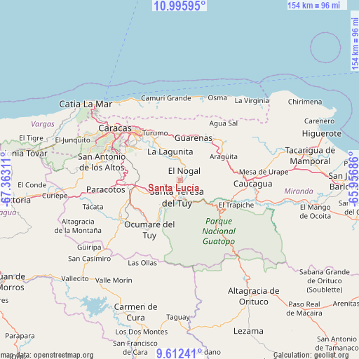
Santa Lucía GPS coordinates[2]
10° 18' 17.784" North, 66° 39' 35.928" West
| Map corner | latitude | longitude |
|---|---|---|
| Upper-left | 10.99595°, | -67.36311° |
| Center: | 10.30494°, | -66.65998° |
| Lower-right: | 9.61241°, | -65.95686° |
| Map W x H: | 153.8×153.8 km | = 95.6×95.6mi |
| max Lat: | 11.94788° ⇑25.7% North |
| Santa Lucía: | 10.30494° |
| min Lat: | ⇓74.3% South 1.92027° |
| min Long | Santa Lucía | max Long |
| -72.55212° | -66.65998° | -60.99778° |
| W 75.6%⇐ | ⇒24.4% E |
Elevation
Elevation of Santa Lucía is 175 m = 574 ft, and this is 205.6 m = 675 ft below average elevation for this country.
| Max E: |
2986 m = 9797 ft | 51.4% |
| Avg. | 380.6 m = 1249 ft | |
| Santa Lucía | 175 m = 574 ft | |
Min E: |
-4 m = -13 ft | 48.6% |
See also: Venezuela elevation on elevation.city.
Geographical zone
Santa Lucía is located in North Torrid zone (between Equator and Tropic of Cancer). Distance of Equator is 1145.8 km =712 mi to South.| Distance of | km | miles | from Santa Lucía |
|---|---|---|---|
| North Pole | 8861.3 | 5506.2 | to North |
| Arctic Circle | 6255.4 | 3886.9 | to North |
| Tropic Cancer | 1460.1 | 907.3 | to North |
| Equator | 1145.8 | 712 | to South |


Nearby cities:
15 places around Santa Lucía: (largest is in red/bold)
• Baruta
27.6 km =17.1 mi,  301°
301°
• Caucaguita
16.7 km =10.4 mi,  290°
290°
• Caucagüito
21.9 km =13.6 mi,  337°
337°
• Charallave
22.7 km =14.1 mi,  252°
252°
• Cúa
29 km =18 mi,  236°
236°
• El Cafetal
25.7 km =16 mi,  313°
313°
• El Hatillo
22.5 km =14 mi, 306°
• Guarenas
18.9 km =11.7 mi,  13°
13°
• Guatire
22.8 km =14.2 mi,  34°
34°
• La Dolorita
24.6 km =15.3 mi,  325°
325°
• Los Dos Caminos
28 km =17.4 mi,  318°
318°
• Ocumare del Tuy
24.3 km =15.1 mi,  211°
211°
• Petare
25 km =15.5 mi, 319°
• San Francisco de Yare
17 km =10.6 mi, 213°
• Santa Teresa del Tuy
8 km =5 mi,  183°
183°
Sources, notices
• [Note1] Compared only with cities in Venezuela existing in our database
• [Src1] Map data: © OpenStreetMap contributors (CC-BY-SA)
• [Src2] Other city data from geonames.org with taken over terms of usage.
• [Src3] Geographical zone / Annual Mean Temperature by Robert A. Rohde @ Wikipedia
