Las Mesas geodata
Las Mesas (Táchira) is a seat of a second-order administrative division; located in Venezuela in America/Caracas (GMT-4) time zone. In our database, there are 108 cities with bigger population. Compared to other cities in Venezuela, 81.9% of cities are located further ↑North; 94.9% of cities are located further →East and 72.8% of cities have lower elevation than Las Mesas. Note1


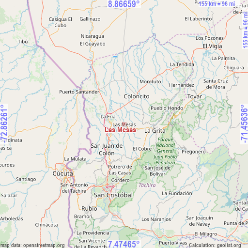
Las Mesas GPS coordinates[2]
8° 10' 16.428" North, 72° 9' 34.128" West
| Map corner | latitude | longitude |
|---|---|---|
| Upper-left | 8.86659°, | -72.86261° |
| Center: | 8.17123°, | -72.15948° |
| Lower-right: | 7.47465°, | -71.45636° |
| Map W x H: | 154.8×154.8 km | = 96.2×96.2mi |
| max Lat: | 11.94788° ⇑81.9% North |
| Las Mesas: | 8.17123° |
| min Lat: | ⇓18.1% South 1.92027° |
| min Long | Las Mesas | max Long |
| -72.55212° | -72.15948° | -60.99778° |
| W 5.1%⇐ | ⇒94.9% E |
Elevation
Elevation of Las Mesas is 484 m = 1588 ft, and this is 103.4 m = 339 ft above average elevation for this country.
| Max E: |
2986 m = 9797 ft | 27.2% |
| Las Mesas | 484 m 1588 ft | |
| Avg. | 380.6 m = 1249 ft | |
Min E: |
-4 m = -13 ft | 72.8% |
See also: Venezuela elevation on elevation.city.
Geographical zone
Las Mesas is located in North Torrid zone (between Equator and Tropic of Cancer). Distance of Equator is 908.6 km =564.6 mi to South.| Distance of | km | miles | from Las Mesas |
|---|---|---|---|
| North Pole | 9098.5 | 5653.5 | to North |
| Arctic Circle | 6492.6 | 4034.3 | to North |
| Tropic Cancer | 1697.4 | 1054.7 | to North |
| Equator | 908.6 | 564.6 | to South |


Nearby cities:
15 places around Las Mesas: (largest is in red/bold)
• Bailadores
37.6 km =23.4 mi,  75°
75°
• Coloncito
19 km =11.8 mi,  24°
24°
• Colón
19.1 km =11.9 mi,  215°
215°
• Cordero
35 km =21.7 mi,  183°
183°
• El Cobre
18.9 km =11.7 mi,  143°
143°
• La Fría
11 km =6.8 mi,  296°
296°
• La Grita
19.8 km =12.3 mi,  102°
102°
• Lobatera
28.5 km =17.7 mi,  199°
199°
• Michelena
25.6 km =15.9 mi, 201°
• Palmira
37.9 km =23.5 mi,  191°
191°
• Queniquea
32.5 km =20.2 mi,  150°
150°
• San José de Bolívar
35.4 km =22 mi, 144°
• Santa Ana
16.3 km =10.1 mi,  111°
111°
• Seboruco
9.9 km =6.2 mi, 107°
• Umuquena
14.9 km =9.3 mi,  44°
44°
Sources, notices
• [Note1] Compared only with cities in Venezuela existing in our database
• [Src1] Map data: © OpenStreetMap contributors (CC-BY-SA)
• [Src2] Other city data from geonames.org with taken over terms of usage.
• [Src3] Geographical zone / Annual Mean Temperature by Robert A. Rohde @ Wikipedia
