La Fría geodata
La Fría (Táchira) is a seat of a second-order administrative division; located in Venezuela in America/Caracas (GMT-4) time zone. With population of 27,077 people, there are 104 cities with bigger population in this country. Compared to other cities in Venezuela, 81.7% of cities are located further ↑North; 97.2% of cities are located further →East and 62.6% of cities have higher elevation than La Fría. Note1


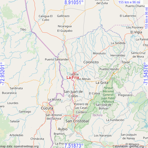
La Fría GPS coordinates[2]
8° 12' 54.828" North, 72° 14' 55.968" West
| Map corner | latitude | longitude |
|---|---|---|
| Upper-left | 8.91051°, | -72.95201° |
| Center: | 8.21523°, | -72.24888° |
| Lower-right: | 7.51873°, | -71.54576° |
| Map W x H: | 154.8×154.8 km | = 96.2×96.2mi |
| max Lat: | 11.94788° ⇑81.7% North |
| La Fría: | 8.21523° |
| min Lat: | ⇓18.3% South 1.92027° |
| min Long | La Fría | max Long |
| -72.55212° | -72.24888° | -60.99778° |
| W 2.8%⇐ | ⇒97.2% E |
Elevation
Elevation of La Fría is 119 m = 390 ft, and this is 261.6 m = 858 ft below average elevation for this country.
| Max E: |
2986 m = 9797 ft | 62.6% |
| Avg. | 380.6 m = 1249 ft | |
| La Fría | 119 m = 390 ft | |
Min E: |
-4 m = -13 ft | 37.4% |
See also: Venezuela elevation on elevation.city.
Geographical zone
La Fría is located in North Torrid zone (between Equator and Tropic of Cancer). Distance of Equator is 913.4 km =567.6 mi to South.| Distance of | km | miles | from La Fría |
|---|---|---|---|
| North Pole | 9093.6 | 5650.5 | to North |
| Arctic Circle | 6487.7 | 4031.3 | to North |
| Tropic Cancer | 1692.5 | 1051.7 | to North |
| Equator | 913.4 | 567.6 | to South |


Nearby cities:
15 places around La Fría: (largest is in red/bold)
• Capacho Viejo
43.6 km =27.1 mi,  190°
190°
• Coloncito
21.6 km =13.4 mi,  55°
55°
• Colón
20.5 km =12.7 mi,  183°
183°
• Cordero
40.5 km =25.2 mi,  169°
169°
• El Cobre
29.1 km =18.1 mi,  133°
133°
• La Grita
30.6 km =19 mi,  107°
107°
• Las Mesas
11 km =6.8 mi,  116°
116°
• Lobatera
31.7 km =19.7 mi, 179°
• Michelena
28.8 km =17.9 mi, 178°
• Palmira
42.1 km =26.2 mi, 176°
• Queniquea
42.1 km =26.2 mi,  142°
142°
• Santa Ana
27.3 km =17 mi, 113°
• Seboruco
20.8 km =12.9 mi, 111°
• Umuquena
21.1 km =13.1 mi,  74°
74°
• Ureña
39.5 km =24.5 mi,  213°
213°
Sources, notices
• [Note1] Compared only with cities in Venezuela existing in our database
• [Src1] Map data: © OpenStreetMap contributors (CC-BY-SA)
• [Src2] Other city data from geonames.org with taken over terms of usage.
• [Src3] Geographical zone / Annual Mean Temperature by Robert A. Rohde @ Wikipedia
