Uyen Hung geodata
Uyen Hung (Gia Lai) is a seat of a second-order administrative division; located in Vietnam in Asia/Ho_Chi_Minh (GMT+7) time zone. In our database, there are 94 cities with bigger population. Compared to other cities in Vietnam, 74.1% of cities are located further ↑North; 71.8% of cities are located further ←West and 66.2% of cities have lower elevation than Uyen Hung. Note1


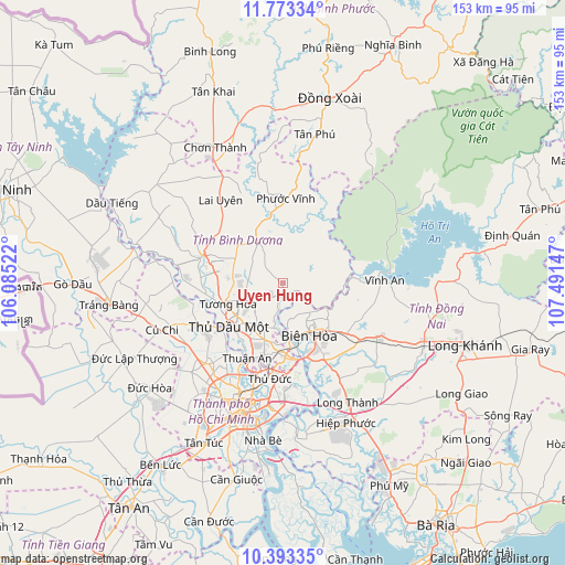
Uyen Hung GPS coordinates[2]
11° 5' 2.976" North, 106° 47' 18.024" East
| Map corner | latitude | longitude |
|---|---|---|
| Upper-left | 11.77334°, | 106.08522° |
| Center: | 11.08416°, | 106.78834° |
| Lower-right: | 10.39335°, | 107.49147° |
| Map W x H: | 153.4×153.4 km | = 95.3×95.3mi |
| max Lat: | 23.27841° ⇑74.1% North |
| Uyen Hung: | 11.08416° |
| min Lat: | ⇓25.9% South 8.65724° |
| min Long | Uyen Hung | max Long |
| 102.4579° | 106.78834° | 112.72541° |
| W 71.8%⇐ | ⇒28.2% E |
Elevation
Elevation of Uyen Hung is 39 m = 128 ft, and this is 90.5 m = 297 ft below average elevation for this country.
| Max E: |
1592 m = 5223 ft | 33.8% |
| Avg. | 129.5 m = 425 ft | |
| Uyen Hung | 39 m = 128 ft | |
Min E: |
-1 m = -3 ft | 66.2% |
See also: Vietnam elevation on elevation.city.
Geographical zone
Uyen Hung is located in North Torrid zone (between Equator and Tropic of Cancer). Distance of Equator is 1232.4 km =765.8 mi to South.| Distance of | km | miles | from Uyen Hung |
|---|---|---|---|
| North Pole | 8774.6 | 5452.3 | to North |
| Arctic Circle | 6168.7 | 3833.1 | to North |
| Tropic Cancer | 1373.5 | 853.5 | to North |
| Equator | 1232.4 | 765.8 | to South |


Nearby cities:
15 places around Uyen Hung: (largest is in red/bold)
• Biên Hòa
16 km =9.9 mi,  165°
165°
• Củ Chi
34.5 km =21.4 mi,  249°
249°
• Dĩ An
19.8 km =12.3 mi,  185°
185°
• Ho Chi Minh City
33.8 km =21 mi,  210°
210°
• Hóc Môn
30.2 km =18.8 mi,  224°
224°
• Lái Thiêu
22.1 km =13.7 mi, 205°
• Quận Bình Thạnh
32.8 km =20.4 mi,  197°
197°
• Quận Chín
27.2 km =16.9 mi,  183°
183°
• Quận Hai
32.8 km =20.4 mi, 187°
• Quận Một
35.1 km =21.8 mi, 196°
• Quận Phú Nhuận
34.4 km =21.4 mi, 200°
• Thủ Dầu Một
18.8 km =11.7 mi,  232°
232°
• Thủ Đức
26.2 km =16.3 mi, 183°
• Trảng Bom
27.8 km =17.3 mi,  121°
121°
• Vĩnh An
26.9 km =16.7 mi,  88°
88°
Sources, notices
• [Note1] Compared only with cities in Vietnam existing in our database
• [Src1] Map data: © OpenStreetMap contributors (CC-BY-SA)
• [Src2] Other city data from geonames.org with taken over terms of usage.
• [Src3] Geographical zone / Annual Mean Temperature by Robert A. Rohde @ Wikipedia
