Cô Tô geodata
Cô Tô (Quảng Ninh) is a seat of a second-order administrative division; located in Vietnam in Asia/Ho_Chi_Minh (GMT+7) time zone. In our database, there are 94 cities with bigger population. Compared to other cities in Vietnam, 73.6% of cities are located further ↓South; 81.6% of cities are located further ←West and 65.4% of cities have higher elevation than Cô Tô. Note1


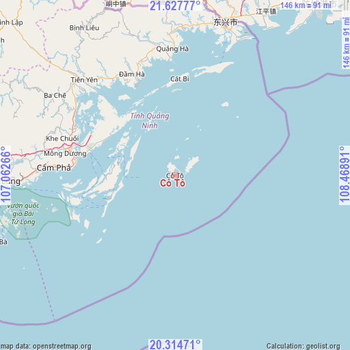
Cô Tô GPS coordinates[2]
20° 58' 21.648" North, 107° 45' 56.808" East
| Map corner | latitude | longitude |
|---|---|---|
| Upper-left | 21.62777°, | 107.06266° |
| Center: | 20.97268°, | 107.76578° |
| Lower-right: | 20.31471°, | 108.46891° |
| Map W x H: | 146×146 km | = 90.7×90.7mi |
| max Lat: | 23.27841° ⇑26.4% North |
| Cô Tô: | 20.97268° |
| min Lat: | ⇓73.6% South 8.65724° |
| min Long | Cô Tô | max Long |
| 102.4579° | 107.76578° | 112.72541° |
| W 81.6%⇐ | ⇒18.4% E |
Elevation
Elevation of Cô Tô is 9 m = 30 ft, and this is 120.5 m = 395 ft below average elevation for this country.
| Max E: |
1592 m = 5223 ft | 65.4% |
| Avg. | 129.5 m = 425 ft | |
| Cô Tô | 9 m = 30 ft | |
Min E: |
-1 m = -3 ft | 34.6% |
See also: Vietnam elevation on elevation.city.
Geographical zone
Cô Tô is located in North Torrid zone (between Equator and Tropic of Cancer). Distance of this Northern Tropic circle is 274 km =170.3 mi to North.| Distance of | km | miles | from Cô Tô |
|---|---|---|---|
| North Pole | 7675.1 | 4769.1 | to North |
| Arctic Circle | 5069.2 | 3149.9 | to North |
| Tropic Cancer | 274 | 170.3 | to North |
| Equator | 2331.9 | 1449 | to South |


Nearby cities:
15 places around Cô Tô: (largest is in red/bold)
• An Châu
103.2 km =64.1 mi,  292°
292°
• An Dương
120.3 km =74.8 mi,  264°
264°
• Cát Bà
79.4 km =49.3 mi,  249°
249°
• Cẩm Phả
51.3 km =31.9 mi,  274°
274°
• Cẩm Phả Mines
48.6 km =30.2 mi,  275°
275°
• Haiphong
113 km =70.2 mi, 263°
• Hạ Long
71.9 km =44.7 mi, 268°
• Móng Cái
64.8 km =40.3 mi,  18°
18°
• Núi Đèo
113.5 km =70.5 mi, 266°
• Núi Đối
116.6 km =72.5 mi, 257°
• Quảng Hà
53.1 km =33 mi,  358°
358°
• Quảng Yên
100.1 km =62.2 mi, 268°
• Thành Phố Uông Bí
103.5 km =64.3 mi, 273°
• Trới
80.7 km =50.1 mi, 274°
• Đình Lập
94.1 km =58.5 mi,  312°
312°
Sources, notices
• [Note1] Compared only with cities in Vietnam existing in our database
• [Src1] Map data: © OpenStreetMap contributors (CC-BY-SA)
• [Src2] Other city data from geonames.org with taken over terms of usage.
• [Src3] Geographical zone / Annual Mean Temperature by Robert A. Rohde @ Wikipedia
