Quảng Hà geodata
Quảng Hà (Quảng Ninh) is a seat of a second-order administrative division; located in Vietnam in Asia/Ho_Chi_Minh (GMT+7) time zone. In our database, there are 94 cities with bigger population. Compared to other cities in Vietnam, 85.2% of cities are located further ↓South; 81.4% of cities are located further ←West and 61.7% of cities have higher elevation than Quảng Hà. Note1


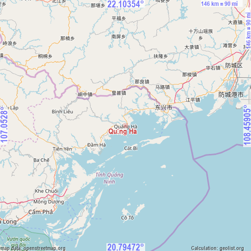
Quảng Hà GPS coordinates[2]
21° 27' 2.16" North, 107° 45' 21.312" East
| Map corner | latitude | longitude |
|---|---|---|
| Upper-left | 22.10354°, | 107.0528° |
| Center: | 21.4506°, | 107.75592° |
| Lower-right: | 20.79472°, | 108.45905° |
| Map W x H: | 145.5×145.5 km | = 90.4×90.4mi |
| max Lat: | 23.27841° ⇑14.8% North |
| Quảng Hà: | 21.4506° |
| min Lat: | ⇓85.2% South 8.65724° |
| min Long | Quảng Hà | max Long |
| 102.4579° | 107.75592° | 112.72541° |
| W 81.4%⇐ | ⇒18.6% E |
Elevation
Elevation of Quảng Hà is 10 m = 33 ft, and this is 119.5 m = 392 ft below average elevation for this country.
| Max E: |
1592 m = 5223 ft | 61.7% |
| Avg. | 129.5 m = 425 ft | |
| Quảng Hà | 10 m = 33 ft | |
Min E: |
-1 m = -3 ft | 38.3% |
See also: Vietnam elevation on elevation.city.
Geographical zone
Quảng Hà is located in North Torrid zone (between Equator and Tropic of Cancer). Distance of this Northern Tropic circle is 220.8 km =137.2 mi to North.| Distance of | km | miles | from Quảng Hà |
|---|---|---|---|
| North Pole | 7622 | 4736.1 | to North |
| Arctic Circle | 5016.1 | 3116.9 | to North |
| Tropic Cancer | 220.8 | 137.2 | to North |
| Equator | 2385.1 | 1482 | to South |


Nearby cities:
15 places around Quảng Hà: (largest is in red/bold)
• An Châu
94.7 km =58.8 mi,  262°
262°
• Chũ
123.4 km =76.7 mi,  266°
266°
• Cát Bà
108.9 km =67.7 mi,  222°
222°
• Cô Tô
53.1 km =33 mi,  178°
178°
• Cẩm Phả
70 km =43.5 mi,  225°
225°
• Cẩm Phả Mines
67.5 km =41.9 mi, 224°
• Hạ Long
90 km =55.9 mi, 231°
• Lạng Sơn
112.1 km =69.7 mi,  293°
293°
• Lộc Bình
92.6 km =57.5 mi, 291°
• Móng Cái
23.3 km =14.5 mi,  69°
69°
• Quảng Yên
113.8 km =70.7 mi,  240°
240°
• Thành Phố Uông Bí
112.1 km =69.7 mi,  245°
245°
• Thị Trấn Cao Lộc
112 km =69.6 mi, 294°
• Trới
92 km =57.2 mi, 239°
• Đình Lập
68.9 km =42.8 mi,  278°
278°
Sources, notices
• [Note1] Compared only with cities in Vietnam existing in our database
• [Src1] Map data: © OpenStreetMap contributors (CC-BY-SA)
• [Src2] Other city data from geonames.org with taken over terms of usage.
• [Src3] Geographical zone / Annual Mean Temperature by Robert A. Rohde @ Wikipedia
