Đồng Nai geodata
Đồng Nai (Lâm Đồng) is a seat of a second-order administrative division; located in Vietnam in Asia/Ho_Chi_Minh (GMT+7) time zone. In our database, there are 94 cities with bigger population. Compared to other cities in Vietnam, 70% of cities are located further ↑North; 78.1% of cities are located further ←West and 78.5% of cities have lower elevation than Đồng Nai. Note1


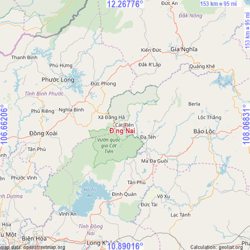
Đồng Nai GPS coordinates[2]
11° 34' 47.316" North, 107° 21' 54.648" East
| Map corner | latitude | longitude |
|---|---|---|
| Upper-left | 12.26776°, | 106.66206° |
| Center: | 11.57981°, | 107.36518° |
| Lower-right: | 10.89016°, | 108.06831° |
| Map W x H: | 153.2×153.2 km | = 95.2×95.2mi |
| max Lat: | 23.27841° ⇑70% North |
| Đồng Nai: | 11.57981° |
| min Lat: | ⇓30% South 8.65724° |
| min Long | Đồng Nai | max Long |
| 102.4579° | 107.36518° | 112.72541° |
| W 78.1%⇐ | ⇒21.9% E |
Elevation
Elevation of Đồng Nai is 140 m = 459 ft, and this is 10.5 m = 34 ft above average elevation for this country.
| Max E: |
1592 m = 5223 ft | 21.5% |
| Đồng Nai | 140 m 459 ft | |
| Avg. | 129.5 m = 425 ft | |
Min E: |
-1 m = -3 ft | 78.5% |
See also: Vietnam elevation on elevation.city.
Geographical zone
Đồng Nai is located in North Torrid zone (between Equator and Tropic of Cancer). Distance of Equator is 1287.6 km =800.1 mi to South.| Distance of | km | miles | from Đồng Nai |
|---|---|---|---|
| North Pole | 8719.5 | 5418 | to North |
| Arctic Circle | 6113.6 | 3798.8 | to North |
| Tropic Cancer | 1318.4 | 819.2 | to North |
| Equator | 1287.6 | 800.1 | to South |


Nearby cities:
15 places around Đồng Nai: (largest is in red/bold)
• Bảo Lộc
48.3 km =30 mi,  94°
94°
• Don Luan
52.7 km =32.7 mi,  264°
264°
• Gia Nghĩa
59 km =36.7 mi,  36°
36°
• Gia Ray
72.8 km =45.2 mi,  176°
176°
• Long Khánh
73.8 km =45.9 mi,  189°
189°
• Lộc Thắng
51.5 km =32 mi,  83°
83°
• Ma Đa Gui
28.3 km =17.6 mi,  139°
139°
• Thống Nhất
73.9 km =45.9 mi,  198°
198°
• Tánh Linh
65 km =40.4 mi,  148°
148°
• Tân Phú
35.1 km =21.8 mi,  167°
167°
• Tân Phú
56 km =34.8 mi, 255°
• Võ Xu
48.6 km =30.2 mi, 154°
• Vĩnh An
65.4 km =40.6 mi,  213°
213°
• Đạ Tẻh
15.7 km =9.8 mi,  119°
119°
• Đức Phong
29.1 km =18.1 mi,  333°
333°
Sources, notices
• [Note1] Compared only with cities in Vietnam existing in our database
• [Src1] Map data: © OpenStreetMap contributors (CC-BY-SA)
• [Src2] Other city data from geonames.org with taken over terms of usage.
• [Src3] Geographical zone / Annual Mean Temperature by Robert A. Rohde @ Wikipedia
