Lộc Thắng geodata
Lộc Thắng (Lâm Đồng) is a seat of a second-order administrative division; located in Vietnam in Asia/Ho_Chi_Minh (GMT+7) time zone. In our database, there are 94 cities with bigger population. Compared to other cities in Vietnam, 69.5% of cities are located further ↑North; 82.4% of cities are located further ←West and 96.9% of cities have lower elevation than Lộc Thắng. Note1


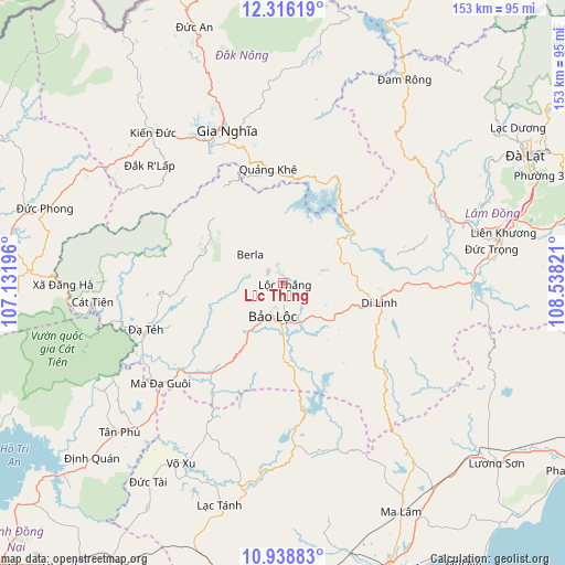
Lộc Thắng GPS coordinates[2]
11° 37' 42.096" North, 107° 50' 6.288" East
| Map corner | latitude | longitude |
|---|---|---|
| Upper-left | 12.31619°, | 107.13196° |
| Center: | 11.62836°, | 107.83508° |
| Lower-right: | 10.93883°, | 108.53821° |
| Map W x H: | 153.1×153.2 km | = 95.1×95.2mi |
| max Lat: | 23.27841° ⇑69.5% North |
| Lộc Thắng: | 11.62836° |
| min Lat: | ⇓30.5% South 8.65724° |
| min Long | Lộc Thắng | max Long |
| 102.4579° | 107.83508° | 112.72541° |
| W 82.4%⇐ | ⇒17.6% E |
Elevation
Elevation of Lộc Thắng is 856 m = 2808 ft, and this is 726.5 m = 2384 ft above average elevation for this country.
| Max E: |
1592 m = 5223 ft | 3.1% |
| Lộc Thắng | 856 m 2808 ft | |
| Avg. | 129.5 m = 425 ft | |
Min E: |
-1 m = -3 ft | 96.9% |
See also: Vietnam elevation on elevation.city.
Geographical zone
Lộc Thắng is located in North Torrid zone (between Equator and Tropic of Cancer). Distance of Equator is 1293 km =803.4 mi to South.| Distance of | km | miles | from Lộc Thắng |
|---|---|---|---|
| North Pole | 8714.1 | 5414.7 | to North |
| Arctic Circle | 6108.2 | 3795.5 | to North |
| Tropic Cancer | 1313 | 815.9 | to North |
| Equator | 1293 | 803.4 | to South |


Nearby cities:
15 places around Lộc Thắng: (largest is in red/bold)
• Bảo Lộc
9.4 km =5.8 mi,  198°
198°
• Di Linh
26.8 km =16.7 mi,  101°
101°
• Gia Nghĩa
44.6 km =27.7 mi,  339°
339°
• Ma Lâm
69.6 km =43.2 mi,  152°
152°
• Ma Đa Gui
42.3 km =26.3 mi,  230°
230°
• Thạnh Mỹ
73.3 km =45.5 mi,  78°
78°
• Tánh Linh
62.8 km =39 mi, 195°
• Tân Phú
58.8 km =36.5 mi, 227°
• Võ Xu
57.5 km =35.7 mi,  211°
211°
• Đinh Văn
47.7 km =29.6 mi,  68°
68°
• Đưc Trọng
59.8 km =37.2 mi, 78°
• Đạ Tẻh
39.7 km =24.7 mi,  250°
250°
• Đắk Song
73.9 km =45.9 mi, 340°
• Đồng Nai
51.5 km =32 mi,  263°
263°
• Đức Phong
67.5 km =41.9 mi,  287°
287°
Sources, notices
• [Note1] Compared only with cities in Vietnam existing in our database
• [Src1] Map data: © OpenStreetMap contributors (CC-BY-SA)
• [Src2] Other city data from geonames.org with taken over terms of usage.
• [Src3] Geographical zone / Annual Mean Temperature by Robert A. Rohde @ Wikipedia
