Don Luan geodata
Don Luan (Bình Phước) is a seat of a first-order administrative division; located in Vietnam in Asia/Ho_Chi_Minh (GMT+7) time zone. With population of 23,978 people, there are 79 cities with bigger population in this country. Compared to other cities in Vietnam, 70.8% of cities are located further ↑North; 72.9% of cities are located further ←West and 74.2% of cities have lower elevation than Don Luan. Note1


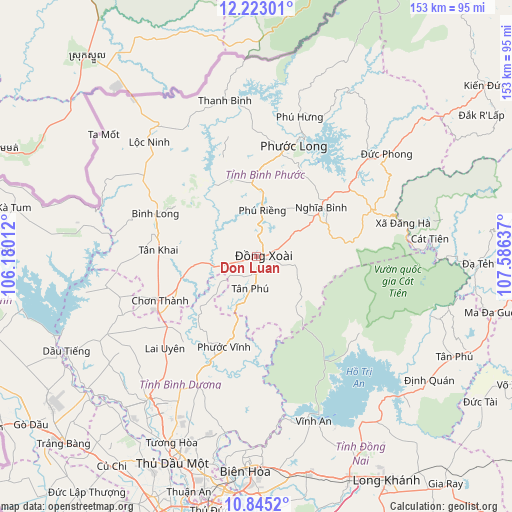
Don Luan GPS coordinates[2]
11° 32' 5.82" North, 106° 52' 59.664" East
| Map corner | latitude | longitude |
|---|---|---|
| Upper-left | 12.22301°, | 106.18012° |
| Center: | 11.53495°, | 106.88324° |
| Lower-right: | 10.8452°, | 107.58637° |
| Map W x H: | 153.2×153.2 km | = 95.2×95.2mi |
| max Lat: | 23.27841° ⇑70.8% North |
| Don Luan: | 11.53495° |
| min Lat: | ⇓29.2% South 8.65724° |
| min Long | Don Luan | max Long |
| 102.4579° | 106.88324° | 112.72541° |
| W 72.9%⇐ | ⇒27.1% E |
Elevation
Elevation of Don Luan is 90 m = 295 ft, and this is 39.5 m = 130 ft below average elevation for this country.
| Max E: |
1592 m = 5223 ft | 25.8% |
| Avg. | 129.5 m = 425 ft | |
| Don Luan | 90 m = 295 ft | |
Min E: |
-1 m = -3 ft | 74.2% |
See also: Vietnam elevation on elevation.city.
Geographical zone
Don Luan is located in North Torrid zone (between Equator and Tropic of Cancer). Distance of Equator is 1282.6 km =797 mi to South.| Distance of | km | miles | from Don Luan |
|---|---|---|---|
| North Pole | 8724.5 | 5421.2 | to North |
| Arctic Circle | 6118.6 | 3801.9 | to North |
| Tropic Cancer | 1323.4 | 822.3 | to North |
| Equator | 1282.6 | 797 | to South |


Nearby cities:
15 places around Don Luan: (largest is in red/bold)
• Biên Hòa
65.9 km =40.9 mi,  185°
185°
• Bình Long
32.7 km =20.3 mi,  292°
292°
• Bù Đốp
47.6 km =29.6 mi,  349°
349°
• Chơn Thành
29.5 km =18.3 mi,  246°
246°
• Dầu Tiếng
64.1 km =39.8 mi,  243°
243°
• Lộc Ninh
46.9 km =29.1 mi,  317°
317°
• Thủ Dầu Một
66.6 km =41.4 mi,  202°
202°
• Trảng Bom
66 km =41 mi,  168°
168°
• Tân Phú
9.5 km =5.9 mi, 190°
• Tân Phú
67 km =41.6 mi,  115°
115°
• Uyen Hung
51.2 km =31.8 mi, 191°
• Vĩnh An
52.3 km =32.5 mi,  161°
161°
• Đạ Tẻh
66.3 km =41.2 mi,  92°
92°
• Đồng Nai
52.7 km =32.7 mi,  84°
84°
• Đức Phong
50 km =31.1 mi,  51°
51°
Sources, notices
• [Note1] Compared only with cities in Vietnam existing in our database
• [Src1] Map data: © OpenStreetMap contributors (CC-BY-SA)
• [Src2] Other city data from geonames.org with taken over terms of usage.
• [Src3] Geographical zone / Annual Mean Temperature by Robert A. Rohde @ Wikipedia
