Châu Thành geodata
Châu Thành (Tây Ninh Province) is a seat of a second-order administrative division; located in Vietnam in Asia/Ho_Chi_Minh (GMT+7) time zone. In our database, there are 94 cities with bigger population. Compared to other cities in Vietnam, 71.9% of cities are located further ↑North; 53.2% of cities are located further →East and 54.8% of cities have higher elevation than Châu Thành. Note1


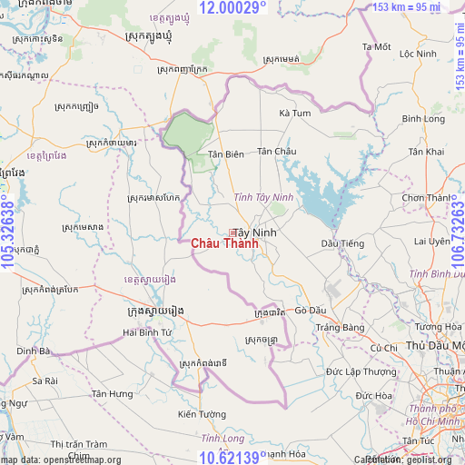
Châu Thành GPS coordinates[2]
11° 18' 42.012" North, 106° 1' 46.2" East
| Map corner | latitude | longitude |
|---|---|---|
| Upper-left | 12.00029°, | 105.32638° |
| Center: | 11.31167°, | 106.0295° |
| Lower-right: | 10.62139°, | 106.73263° |
| Map W x H: | 153.3×153.3 km | = 95.3×95.3mi |
| max Lat: | 23.27841° ⇑71.9% North |
| Châu Thành: | 11.31167° |
| min Lat: | ⇓28.1% South 8.65724° |
| min Long | Châu Thành | max Long |
| 102.4579° | 106.0295° | 112.72541° |
| W 46.8%⇐ | ⇒53.2% E |
Elevation
Elevation of Châu Thành is 12 m = 39 ft, and this is 117.5 m = 385 ft below average elevation for this country.
| Max E: |
1592 m = 5223 ft | 54.8% |
| Avg. | 129.5 m = 425 ft | |
| Châu Thành | 12 m = 39 ft | |
Min E: |
-1 m = -3 ft | 45.2% |
See also: Vietnam elevation on elevation.city.
Geographical zone
Châu Thành is located in North Torrid zone (between Equator and Tropic of Cancer). Distance of Equator is 1257.7 km =781.5 mi to South.| Distance of | km | miles | from Châu Thành |
|---|---|---|---|
| North Pole | 8749.3 | 5436.6 | to North |
| Arctic Circle | 6143.4 | 3817.3 | to North |
| Tropic Cancer | 1348.2 | 837.7 | to North |
| Equator | 1257.7 | 781.5 | to South |


Nearby cities:
15 places around Châu Thành: (largest is in red/bold)
• Bến Cầu
27.7 km =17.2 mi,  143°
143°
• Củ Chi
63 km =39.1 mi,  126°
126°
• Dương Minh Châu
23.4 km =14.5 mi,  69°
69°
• Dầu Tiếng
36.1 km =22.4 mi,  96°
96°
• Gò Dầu
35.6 km =22.1 mi, 134°
• Hòa Thành
11.2 km =7 mi, 104°
• Hậu Nghĩa
61.3 km =38.1 mi, 139°
• Phú Khương
11.8 km =7.3 mi,  105°
105°
• Trảng Bàng
47.6 km =29.6 mi, 131°
• Tân Biên
26 km =16.2 mi,  355°
355°
• Tân Châu
30.9 km =19.2 mi,  30°
30°
• Tân Hưng
66.5 km =41.3 mi,  217°
217°
• Tây Ninh
7.5 km =4.7 mi,  91°
91°
• Vĩnh Hưng
53.9 km =33.5 mi,  209°
209°
• Đông Thành
55.6 km =34.5 mi,  147°
147°
Sources, notices
• [Note1] Compared only with cities in Vietnam existing in our database
• [Src1] Map data: © OpenStreetMap contributors (CC-BY-SA)
• [Src2] Other city data from geonames.org with taken over terms of usage.
• [Src3] Geographical zone / Annual Mean Temperature by Robert A. Rohde @ Wikipedia
