Chợ Mới geodata
Chợ Mới (Bắc Kạn) is a seat of a second-order administrative division; located in Vietnam in Asia/Ho_Chi_Minh (GMT+7) time zone. In our database, there are 94 cities with bigger population. Compared to other cities in Vietnam, 90% of cities are located further ↓South; 65.1% of cities are located further →East and 71.3% of cities have lower elevation than Chợ Mới. Note1


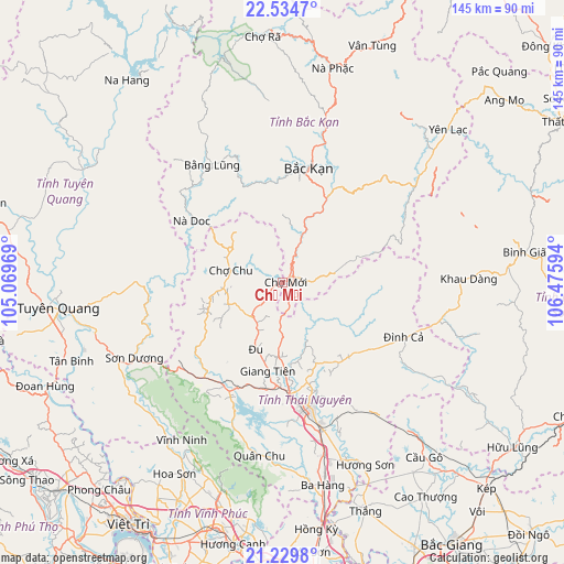
Chợ Mới GPS coordinates[2]
21° 53' 1.464" North, 105° 46' 22.116" East
| Map corner | latitude | longitude |
|---|---|---|
| Upper-left | 22.5347°, | 105.06969° |
| Center: | 21.88374°, | 105.77281° |
| Lower-right: | 21.2298°, | 106.47594° |
| Map W x H: | 145.1×145.1 km | = 90.2×90.2mi |
| max Lat: | 23.27841° ⇑10% North |
| Chợ Mới: | 21.88374° |
| min Lat: | ⇓90% South 8.65724° |
| min Long | Chợ Mới | max Long |
| 102.4579° | 105.77281° | 112.72541° |
| W 34.9%⇐ | ⇒65.1% E |
Elevation
Elevation of Chợ Mới is 63 m = 207 ft, and this is 66.5 m = 218 ft below average elevation for this country.
| Max E: |
1592 m = 5223 ft | 28.7% |
| Avg. | 129.5 m = 425 ft | |
| Chợ Mới | 63 m = 207 ft | |
Min E: |
-1 m = -3 ft | 71.3% |
See also: Vietnam elevation on elevation.city.
Geographical zone
Chợ Mới is located in North Torrid zone (between Equator and Tropic of Cancer). Distance of this Northern Tropic circle is 172.7 km =107.3 mi to North.| Distance of | km | miles | from Chợ Mới |
|---|---|---|---|
| North Pole | 7573.8 | 4706.1 | to North |
| Arctic Circle | 4967.9 | 3086.9 | to North |
| Tropic Cancer | 172.7 | 107.3 | to North |
| Equator | 2433.2 | 1511.9 | to South |


Nearby cities:
15 places around Chợ Mới: (largest is in red/bold)
• Bắc Kạn
30 km =18.6 mi,  12°
12°
• Bắc Sơn
56.6 km =35.2 mi,  88°
88°
• Bằng Lũng
35.5 km =22.1 mi,  329°
329°
• Chùa Hang
29.8 km =18.5 mi,  166°
166°
• Chợ Chu
13.7 km =8.5 mi,  280°
280°
• Cầu Gồ
58.2 km =36.2 mi,  141°
141°
• Huyện Chiêm Hóa
59.1 km =36.7 mi,  299°
299°
• Hương Sơn
51.7 km =32.1 mi,  155°
155°
• Phủ Thông
44.7 km =27.8 mi, 14°
• Sơn Dương
43.8 km =27.2 mi,  241°
241°
• Thái Nguyên
33.1 km =20.6 mi, 166°
• Trai Ngau
56.9 km =35.4 mi,  196°
196°
• Tuyên Quang
58 km =36 mi,  263°
263°
• Yến Lạc
57.6 km =35.8 mi,  47°
47°
• Đu
17.7 km =11 mi, 203°
Sources, notices
• [Note1] Compared only with cities in Vietnam existing in our database
• [Src1] Map data: © OpenStreetMap contributors (CC-BY-SA)
• [Src2] Other city data from geonames.org with taken over terms of usage.
• [Src3] Geographical zone / Annual Mean Temperature by Robert A. Rohde @ Wikipedia
