Bắc Kạn geodata
Bắc Kạn is a seat of a first-order administrative division; located in Vietnam in Asia/Ho_Chi_Minh (GMT+7) time zone. With population of 17,701 people, there are 83 cities with bigger population in this country. Compared to other cities in Vietnam, 91.8% of cities are located further ↓South; 62.5% of cities are located further →East and 79.1% of cities have lower elevation than Bắc Kạn. Note1


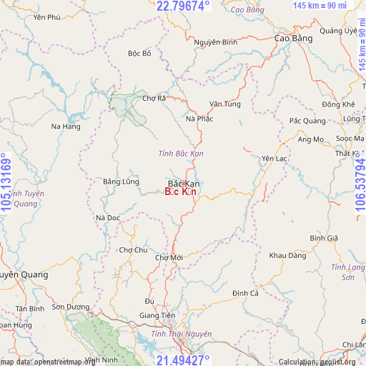
Bắc Kạn GPS coordinates[2]
22° 8' 49.236" North, 105° 50' 5.316" East
| Map corner | latitude | longitude |
|---|---|---|
| Upper-left | 22.79674°, | 105.13169° |
| Center: | 22.14701°, | 105.83481° |
| Lower-right: | 21.49427°, | 106.53794° |
| Map W x H: | 144.8×144.8 km | = 90×90mi |
| max Lat: | 23.27841° ⇑8.2% North |
| Bắc Kạn: | 22.14701° |
| min Lat: | ⇓91.8% South 8.65724° |
| min Long | Bắc Kạn | max Long |
| 102.4579° | 105.83481° | 112.72541° |
| W 37.5%⇐ | ⇒62.5% E |
Elevation
Elevation of Bắc Kạn is 150 m = 492 ft, and this is 20.5 m = 67 ft above average elevation for this country.
| Max E: |
1592 m = 5223 ft | 20.9% |
| Bắc Kạn | 150 m 492 ft | |
| Avg. | 129.5 m = 425 ft | |
Min E: |
-1 m = -3 ft | 79.1% |
See also: Vietnam elevation on elevation.city.
Geographical zone
Bắc Kạn is located in North Torrid zone (between Equator and Tropic of Cancer). Distance of this Northern Tropic circle is 143.4 km =89.1 mi to North.| Distance of | km | miles | from Bắc Kạn |
|---|---|---|---|
| North Pole | 7544.5 | 4687.9 | to North |
| Arctic Circle | 4938.7 | 3068.8 | to North |
| Tropic Cancer | 143.4 | 89.1 | to North |
| Equator | 2462.5 | 1530.1 | to South |


Nearby cities:
15 places around Bắc Kạn: (largest is in red/bold)
• Bình Gia
58.4 km =36.3 mi,  110°
110°
• Bắc Sơn
57.1 km =35.5 mi,  118°
118°
• Bằng Lũng
24.7 km =15.3 mi,  272°
272°
• Bộc Bố
54.5 km =33.9 mi,  341°
341°
• Chùa Hang
58.2 km =36.2 mi,  179°
179°
• Chợ Chu
33.2 km =20.6 mi,  216°
216°
• Chợ Mới
30 km =18.6 mi,  192°
192°
• Huyện Chiêm Hóa
57.9 km =36 mi, 269°
• Phủ Thông
14.8 km =9.2 mi,  18°
18°
• Thị Trấn Na Hang
51.7 km =32.1 mi,  295°
295°
• Thị Trấn Nguyên Bình
57.4 km =35.7 mi,  12°
12°
• Thị Trấn Vĩnh Lộc
58 km =36 mi, 269°
• Vân Tùng
35.7 km =22.2 mi,  27°
27°
• Yến Lạc
37.1 km =23.1 mi,  74°
74°
• Đu
47.4 km =29.5 mi,  196°
196°
Sources, notices
• [Note1] Compared only with cities in Vietnam existing in our database
• [Src1] Map data: © OpenStreetMap contributors (CC-BY-SA)
• [Src2] Other city data from geonames.org with taken over terms of usage.
• [Src3] Geographical zone / Annual Mean Temperature by Robert A. Rohde @ Wikipedia
