Phan Thiết geodata
Phan Thiết (Bình Thuận) is a seat of a first-order administrative division; located in Vietnam in Asia/Ho_Chi_Minh (GMT+7) time zone. With population of 160,652 people, there are 17 cities with bigger population in this country. Compared to other cities in Vietnam, 75.4% of cities are located further ↑North; 85.6% of cities are located further ←West and 61.7% of cities have higher elevation than Phan Thiết. Note1


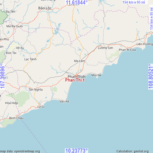
Phan Thiết GPS coordinates[2]
10° 55' 44.004" North, 108° 6' 7.488" East
| Map corner | latitude | longitude |
|---|---|---|
| Upper-left | 11.61844°, | 107.39896° |
| Center: | 10.92889°, | 108.10208° |
| Lower-right: | 10.23773°, | 108.80521° |
| Map W x H: | 153.5×153.5 km | = 95.4×95.4mi |
| max Lat: | 23.27841° ⇑75.4% North |
| Phan Thiết: | 10.92889° |
| min Lat: | ⇓24.6% South 8.65724° |
| min Long | Phan Thiết | max Long |
| 102.4579° | 108.10208° | 112.72541° |
| W 85.6%⇐ | ⇒14.4% E |
Elevation
Elevation of Phan Thiết is 10 m = 33 ft, and this is 119.5 m = 392 ft below average elevation for this country.
| Max E: |
1592 m = 5223 ft | 61.7% |
| Avg. | 129.5 m = 425 ft | |
| Phan Thiết | 10 m = 33 ft | |
Min E: |
-1 m = -3 ft | 38.3% |
See also: Phan Thiết elevation on elevation.city.
Geographical zone
Phan Thiết is located in North Torrid zone (between Equator and Tropic of Cancer). Distance of Equator is 1215.2 km =755.1 mi to South.| Distance of | km | miles | from Phan Thiết |
|---|---|---|---|
| North Pole | 8791.9 | 5463 | to North |
| Arctic Circle | 6186 | 3843.8 | to North |
| Tropic Cancer | 1390.7 | 864.1 | to North |
| Equator | 1215.2 | 755.1 | to South |


Nearby cities:
15 places around Phan Thiết: (largest is in red/bold)
• Bảo Lộc
76 km =47.2 mi,  334°
334°
• Chợ Lầu
54.9 km =34.1 mi,  53°
53°
• Di Linh
72.6 km =45.1 mi,  357°
357°
• Gia Ray
76.5 km =47.5 mi,  269°
269°
• La Gi
46.8 km =29.1 mi,  230°
230°
• Liên Hương
75.5 km =46.9 mi,  63°
63°
• Lộc Thắng
83 km =51.6 mi,  339°
339°
• Ma Lâm
16.3 km =10.1 mi,  10°
10°
• Ma Đa Gui
80.1 km =49.8 mi,  309°
309°
• Thuận Nam
25.9 km =16.1 mi,  250°
250°
• Thị Trấn Phước Bửu
88.1 km =54.7 mi,  240°
240°
• Tánh Linh
49.1 km =30.5 mi,  290°
290°
• Tân Phú
82 km =51 mi,  297°
297°
• Võ Xu
65.7 km =40.8 mi, 295°
• Đạ Tẻh
92.9 km =57.7 mi, 314°
Sources, notices
• [Note1] Compared only with cities in Vietnam existing in our database
• [Src1] Map data: © OpenStreetMap contributors (CC-BY-SA)
• [Src2] Other city data from geonames.org with taken over terms of usage.
• [Src3] Geographical zone / Annual Mean Temperature by Robert A. Rohde @ Wikipedia
