La Gi geodata
La Gi (Bình Thuận) is a populated place; located in Vietnam in Asia/Ho_Chi_Minh (GMT+7) time zone. With population of 160,652 people, there are 17 cities with bigger population in this country. Compared to other cities in Vietnam, 81.1% of cities are located further ↑North; 81.7% of cities are located further ←West and 71.9% of cities have higher elevation than La Gi. Note1


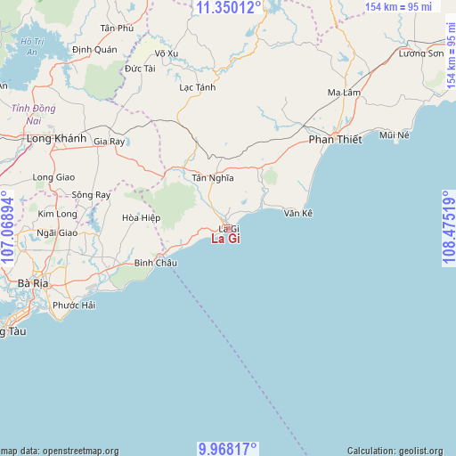
La Gi GPS coordinates[2]
10° 39' 35.748" North, 107° 46' 19.416" East
| Map corner | latitude | longitude |
|---|---|---|
| Upper-left | 11.35012°, | 107.06894° |
| Center: | 10.65993°, | 107.77206° |
| Lower-right: | 9.96817°, | 108.47519° |
| Map W x H: | 153.7×153.7 km | = 95.5×95.5mi |
| max Lat: | 23.27841° ⇑81.1% North |
| La Gi: | 10.65993° |
| min Lat: | ⇓18.9% South 8.65724° |
| min Long | La Gi | max Long |
| 102.4579° | 107.77206° | 112.72541° |
| W 81.7%⇐ | ⇒18.3% E |
Elevation
Elevation of La Gi is 8 m = 26 ft, and this is 121.5 m = 399 ft below average elevation for this country.
| Max E: |
1592 m = 5223 ft | 71.9% |
| Avg. | 129.5 m = 425 ft | |
| La Gi | 8 m = 26 ft | |
Min E: |
-1 m = -3 ft | 28.1% |
See also: La Gi elevation on elevation.city.
Geographical zone
La Gi is located in North Torrid zone (between Equator and Tropic of Cancer). Distance of Equator is 1185.3 km =736.5 mi to South.| Distance of | km | miles | from La Gi |
|---|---|---|---|
| North Pole | 8821.8 | 5481.6 | to North |
| Arctic Circle | 6215.9 | 3862.4 | to North |
| Tropic Cancer | 1420.6 | 882.7 | to North |
| Equator | 1185.3 | 736.5 | to South |


Nearby cities:
15 places around La Gi: (largest is in red/bold)
• Gia Ray
50.1 km =31.1 mi,  306°
306°
• Long Khánh
64.5 km =40.1 mi,  297°
297°
• Ma Lâm
60.3 km =37.5 mi,  40°
40°
• Phan Thiết
46.8 km =29.1 mi,  50°
50°
• Phuoc Tho
58 km =36 mi,  251°
251°
• Thuận Nam
24.1 km =15 mi,  28°
28°
• Thành Phố Bà Rịa
68.4 km =42.5 mi, 254°
• Thị Trấn Long Điền
64.2 km =39.9 mi, 252°
• Thị Trấn Ngải Giao
57.5 km =35.7 mi,  268°
268°
• Thị Trấn Phước Bửu
42.8 km =26.6 mi, 251°
• Thị Xã Phú Mỹ
70.9 km =44.1 mi,  261°
261°
• Thống Nhất
75.7 km =47 mi, 295°
• Tánh Linh
48.2 km =30 mi,  348°
348°
• Tân Phú
77.3 km =48 mi,  331°
331°
• Võ Xu
63 km =39.1 mi,  338°
338°
Sources, notices
• [Note1] Compared only with cities in Vietnam existing in our database
• [Src1] Map data: © OpenStreetMap contributors (CC-BY-SA)
• [Src2] Other city data from geonames.org with taken over terms of usage.
• [Src3] Geographical zone / Annual Mean Temperature by Robert A. Rohde @ Wikipedia
