Việt Trì geodata
Việt Trì (Phú Thọ) is a seat of a first-order administrative division; located in Vietnam in Asia/Ho_Chi_Minh (GMT+7) time zone. With population of 93,475 people, there are 38 cities with bigger population in this country. Compared to other cities in Vietnam, 82.7% of cities are located further ↓South; 80.1% of cities are located further →East and 61.3% of cities have lower elevation than Việt Trì. Note1


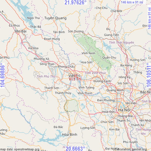
Việt Trì GPS coordinates[2]
21° 19' 21.864" North, 105° 24' 7.128" East
| Map corner | latitude | longitude |
|---|---|---|
| Upper-left | 21.97626°, | 104.69886° |
| Center: | 21.32274°, | 105.40198° |
| Lower-right: | 20.6663°, | 106.10511° |
| Map W x H: | 145.7×145.7 km | = 90.5×90.5mi |
| max Lat: | 23.27841° ⇑17.3% North |
| Việt Trì: | 21.32274° |
| min Lat: | ⇓82.7% South 8.65724° |
| min Long | Việt Trì | max Long |
| 102.4579° | 105.40198° | 112.72541° |
| W 19.9%⇐ | ⇒80.1% E |
Elevation
Elevation of Việt Trì is 25 m = 82 ft, and this is 104.5 m = 343 ft below average elevation for this country.
| Max E: |
1592 m = 5223 ft | 38.7% |
| Avg. | 129.5 m = 425 ft | |
| Việt Trì | 25 m = 82 ft | |
Min E: |
-1 m = -3 ft | 61.3% |
See also: Việt Trì elevation on elevation.city.
Geographical zone
Việt Trì is located in North Torrid zone (between Equator and Tropic of Cancer). Distance of this Northern Tropic circle is 235.1 km =146.1 mi to North.| Distance of | km | miles | from Việt Trì |
|---|---|---|---|
| North Pole | 7636.2 | 4744.9 | to North |
| Arctic Circle | 5030.3 | 3125.7 | to North |
| Tropic Cancer | 235.1 | 146.1 | to North |
| Equator | 2370.9 | 1473.2 | to South |


Nearby cities:
15 places around Việt Trì: (largest is in red/bold)
• Hưng Hóa
13.4 km =8.3 mi,  235°
235°
• Hương Canh
25.8 km =16 mi,  100°
100°
• Hợp Hòa
15.7 km =9.8 mi,  68°
68°
• Lâm Thao
11.4 km =7.1 mi,  268°
268°
• Lập Thạch
12 km =7.5 mi,  30°
30°
• Phong Châu
13.2 km =8.2 mi,  315°
315°
• Phú Thọ
20.5 km =12.7 mi,  294°
294°
• Sơn Tây
23 km =14.3 mi,  151°
151°
• Thanh Sơn
26.9 km =16.7 mi, 239°
• Thanh Thủy
20.4 km =12.7 mi,  216°
216°
• Trai Ngau
23.4 km =14.5 mi, 70°
• Tây Đằng
14 km =8.7 mi,  171°
171°
• Vĩnh Tường
16.5 km =10.3 mi,  135°
135°
• Vĩnh Yên
21.1 km =13.1 mi,  94°
94°
• Yên Lạc
20.1 km =12.5 mi,  118°
118°
Sources, notices
• [Note1] Compared only with cities in Vietnam existing in our database
• [Src1] Map data: © OpenStreetMap contributors (CC-BY-SA)
• [Src2] Other city data from geonames.org with taken over terms of usage.
• [Src3] Geographical zone / Annual Mean Temperature by Robert A. Rohde @ Wikipedia
