Long Hồ geodata
Long Hồ (Vĩnh Long) is a seat of a second-order administrative division; located in Vietnam in Asia/Ho_Chi_Minh (GMT+7) time zone. In our database, there are 94 cities with bigger population. Compared to other cities in Vietnam, 89.6% of cities are located further ↑North; 53.8% of cities are located further →East and 95.4% of cities have higher elevation than Long Hồ. Note1


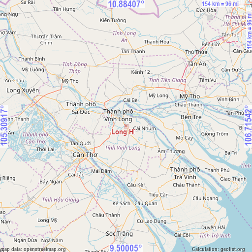
Long Hồ GPS coordinates[2]
10° 11' 34.116" North, 106° 0' 44.244" East
| Map corner | latitude | longitude |
|---|---|---|
| Upper-left | 10.88407°, | 105.30917° |
| Center: | 10.19281°, | 106.01229° |
| Lower-right: | 9.50005°, | 106.71542° |
| Map W x H: | 153.9×153.9 km | = 95.6×95.6mi |
| max Lat: | 23.27841° ⇑89.6% North |
| Long Hồ: | 10.19281° |
| min Lat: | ⇓10.4% South 8.65724° |
| min Long | Long Hồ | max Long |
| 102.4579° | 106.01229° | 112.72541° |
| W 46.2%⇐ | ⇒53.8% E |
Elevation
Elevation of Long Hồ is 3 m = 10 ft, and this is 126.5 m = 415 ft below average elevation for this country.
| Max E: |
1592 m = 5223 ft | 95.4% |
| Avg. | 129.5 m = 425 ft | |
| Long Hồ | 3 m = 10 ft | |
Min E: |
-1 m = -3 ft | 4.6% |
See also: Vietnam elevation on elevation.city.
Geographical zone
Long Hồ is located in North Torrid zone (between Equator and Tropic of Cancer). Distance of Equator is 1133.3 km =704.2 mi to South.| Distance of | km | miles | from Long Hồ |
|---|---|---|---|
| North Pole | 8873.7 | 5513.9 | to North |
| Arctic Circle | 6267.8 | 3894.6 | to North |
| Tropic Cancer | 1472.6 | 915 | to North |
| Equator | 1133.3 | 704.2 | to South |


Nearby cities:
15 places around Long Hồ: (largest is in red/bold)
• An Hòa
31.5 km =19.6 mi,  291°
291°
• Bình Minh
25 km =15.5 mi,  236°
236°
• Bình Thủy
32.6 km =20.3 mi,  246°
246°
• Chợ Lách
13.9 km =8.6 mi,  57°
57°
• Cái Nhum
10.9 km =6.8 mi,  100°
100°
• Cái Răng
35.7 km =22.2 mi,  233°
233°
• Cái Tàu Hạ
17.2 km =10.7 mi,  295°
295°
• Cần Thơ
30 km =18.6 mi, 234°
• Cầu Kè
35.9 km =22.3 mi,  172°
172°
• Sa Dec
30.1 km =18.7 mi, 291°
• Tam Bình
16.1 km =10 mi,  184°
184°
• Trà Ôn
27.5 km =17.1 mi,  201°
201°
• Vĩnh Long
8.1 km =5 mi,  327°
327°
• Vũng Liêm
21.8 km =13.5 mi,  119°
119°
• Ấp Tân Ngãi
30 km =18.6 mi,  81°
81°
Sources, notices
• [Note1] Compared only with cities in Vietnam existing in our database
• [Src1] Map data: © OpenStreetMap contributors (CC-BY-SA)
• [Src2] Other city data from geonames.org with taken over terms of usage.
• [Src3] Geographical zone / Annual Mean Temperature by Robert A. Rohde @ Wikipedia
