Liên Hương geodata
Liên Hương (Bình Thuận) is a seat of a second-order administrative division; located in Vietnam in Asia/Ho_Chi_Minh (GMT+7) time zone. In our database, there are 94 cities with bigger population. Compared to other cities in Vietnam, 72.9% of cities are located further ↑North; 93.1% of cities are located further ←West and 53.3% of cities have lower elevation than Liên Hương. Note1


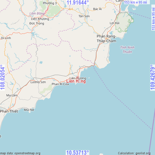
Liên Hương GPS coordinates[2]
11° 13' 39.396" North, 108° 43' 25.176" East
| Map corner | latitude | longitude |
|---|---|---|
| Upper-left | 11.91644°, | 108.02054° |
| Center: | 11.22761°, | 108.72366° |
| Lower-right: | 10.53713°, | 109.42679° |
| Map W x H: | 153.4×153.4 km | = 95.3×95.3mi |
| max Lat: | 23.27841° ⇑72.9% North |
| Liên Hương: | 11.22761° |
| min Lat: | ⇓27.1% South 8.65724° |
| min Long | Liên Hương | max Long |
| 102.4579° | 108.72366° | 112.72541° |
| W 93.1%⇐ | ⇒6.9% E |
Elevation
Elevation of Liên Hương is 16 m = 52 ft, and this is 113.5 m = 372 ft below average elevation for this country.
| Max E: |
1592 m = 5223 ft | 46.7% |
| Avg. | 129.5 m = 425 ft | |
| Liên Hương | 16 m = 52 ft | |
Min E: |
-1 m = -3 ft | 53.3% |
See also: Vietnam elevation on elevation.city.
Geographical zone
Liên Hương is located in North Torrid zone (between Equator and Tropic of Cancer). Distance of Equator is 1248.4 km =775.7 mi to South.| Distance of | km | miles | from Liên Hương |
|---|---|---|---|
| North Pole | 8758.7 | 5442.4 | to North |
| Arctic Circle | 6152.8 | 3823.2 | to North |
| Tropic Cancer | 1357.5 | 843.5 | to North |
| Equator | 1248.4 | 775.7 | to South |


Nearby cities:
15 places around Liên Hương: (largest is in red/bold)
• Bác Ái
71 km =44.1 mi,  15°
15°
• Chợ Lầu
23.6 km =14.7 mi,  268°
268°
• Di Linh
80.8 km =50.2 mi,  299°
299°
• Khánh Hải
53.2 km =33.1 mi,  40°
40°
• Ma Lâm
67 km =41.6 mi,  255°
255°
• Phan Rang-Tháp Chàm
47.3 km =29.4 mi, 37°
• Phan Thiết
75.5 km =46.9 mi,  243°
243°
• Phú Quý
82.3 km =51.1 mi,  163°
163°
• Phước Dân
40.2 km =25 mi,  34°
34°
• Thạnh Mỹ
64.4 km =40 mi,  337°
337°
• Tân Sơn
61.3 km =38.1 mi,  6°
6°
• Tô Hạp
89.9 km =55.9 mi, 15°
• Ðà Lạt
85.6 km =53.2 mi, 338°
• Đinh Văn
81.3 km =50.5 mi,  319°
319°
• Đưc Trọng
68.2 km =42.4 mi,  325°
325°
Sources, notices
• [Note1] Compared only with cities in Vietnam existing in our database
• [Src1] Map data: © OpenStreetMap contributors (CC-BY-SA)
• [Src2] Other city data from geonames.org with taken over terms of usage.
• [Src3] Geographical zone / Annual Mean Temperature by Robert A. Rohde @ Wikipedia
