Di Linh geodata
Di Linh (Lâm Đồng) is a seat of a second-order administrative division; located in Vietnam in Asia/Ho_Chi_Minh (GMT+7) time zone. In our database, there are 94 cities with bigger population. Compared to other cities in Vietnam, 69.8% of cities are located further ↑North; 85.2% of cities are located further ←West and 98.2% of cities have lower elevation than Di Linh. Note1


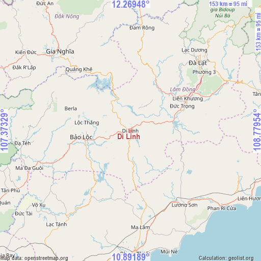
Di Linh GPS coordinates[2]
11° 34' 53.508" North, 108° 4' 35.076" East
| Map corner | latitude | longitude |
|---|---|---|
| Upper-left | 12.26948°, | 107.37329° |
| Center: | 11.58153°, | 108.07641° |
| Lower-right: | 10.89189°, | 108.77954° |
| Map W x H: | 153.2×153.2 km | = 95.2×95.2mi |
| max Lat: | 23.27841° ⇑69.8% North |
| Di Linh: | 11.58153° |
| min Lat: | ⇓30.2% South 8.65724° |
| min Long | Di Linh | max Long |
| 102.4579° | 108.07641° | 112.72541° |
| W 85.2%⇐ | ⇒14.8% E |
Elevation
Elevation of Di Linh is 978 m = 3209 ft, and this is 848.5 m = 2784 ft above average elevation for this country.
| Max E: |
1592 m = 5223 ft | 1.8% |
| Di Linh | 978 m 3209 ft | |
| Avg. | 129.5 m = 425 ft | |
Min E: |
-1 m = -3 ft | 98.2% |
See also: Vietnam elevation on elevation.city.
Geographical zone
Di Linh is located in North Torrid zone (between Equator and Tropic of Cancer). Distance of Equator is 1287.7 km =800.1 mi to South.| Distance of | km | miles | from Di Linh |
|---|---|---|---|
| North Pole | 8719.3 | 5417.9 | to North |
| Arctic Circle | 6113.4 | 3798.7 | to North |
| Tropic Cancer | 1318.2 | 819.1 | to North |
| Equator | 1287.7 | 800.1 | to South |


Nearby cities:
15 places around Di Linh: (largest is in red/bold)
• Bảo Lộc
29.5 km =18.3 mi,  262°
262°
• Chợ Lầu
61.7 km =38.3 mi,  130°
130°
• Gia Nghĩa
63 km =39.1 mi,  318°
318°
• Lạc Dương
60 km =37.3 mi,  38°
38°
• Lộc Thắng
26.8 km =16.7 mi,  281°
281°
• Ma Lâm
56.8 km =35.3 mi,  174°
174°
• Ma Đa Gui
62.8 km =39 mi,  249°
249°
• Phan Thiết
72.6 km =45.1 mi,  177°
177°
• Thạnh Mỹ
49.8 km =30.9 mi,  66°
66°
• Tánh Linh
70.1 km =43.6 mi,  217°
217°
• Võ Xu
71.3 km =44.3 mi,  232°
232°
• Ðà Lạt
56.8 km =35.3 mi, 44°
• Đinh Văn
29.1 km =18.1 mi, 38°
• Đưc Trọng
36.6 km =22.7 mi,  62°
62°
• Đạ Tẻh
64.3 km =40 mi, 263°
Sources, notices
• [Note1] Compared only with cities in Vietnam existing in our database
• [Src1] Map data: © OpenStreetMap contributors (CC-BY-SA)
• [Src2] Other city data from geonames.org with taken over terms of usage.
• [Src3] Geographical zone / Annual Mean Temperature by Robert A. Rohde @ Wikipedia
