Phan Rang-Tháp Chàm geodata
Phan Rang-Tháp Chàm (Ninh Thuận) is a seat of a first-order administrative division; located in Vietnam in Asia/Ho_Chi_Minh (GMT+7) time zone. With population of 91,520 people, there are 39 cities with bigger population in this country. Compared to other cities in Vietnam, 70.1% of cities are located further ↑North; 96.7% of cities are located further ←West and 71.9% of cities have higher elevation than Phan Rang-Tháp Chàm. Note1


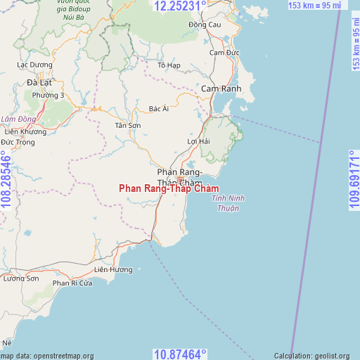
Phan Rang-Tháp Chàm GPS coordinates[2]
11° 33' 51.552" North, 108° 59' 18.888" East
| Map corner | latitude | longitude |
|---|---|---|
| Upper-left | 12.25231°, | 108.28546° |
| Center: | 11.56432°, | 108.98858° |
| Lower-right: | 10.87464°, | 109.69171° |
| Map W x H: | 153.2×153.2 km | = 95.2×95.2mi |
| max Lat: | 23.27841° ⇑70.1% North |
| Phan Rang-Tháp Chàm: | 11.56432° |
| min Lat: | ⇓29.9% South 8.65724° |
| min Long | Phan Rang-Tháp | max Long |
| 102.4579° | 108.98858° | 112.72541° |
| W 96.7%⇐ | ⇒3.3% E |
Elevation
Elevation of Phan Rang-Tháp Chàm is 8 m = 26 ft, and this is 121.5 m = 399 ft below average elevation for this country.
| Max E: |
1592 m = 5223 ft | 71.9% |
| Avg. | 129.5 m = 425 ft | |
| Phan Rang-Tháp Chàm | 8 m = 26 ft | |
Min E: |
-1 m = -3 ft | 28.1% |
See also: Phan Rang-Tháp Chàm elevation on elevation.city.
Geographical zone
Phan Rang-Tháp Chàm is located in North Torrid zone (between Equator and Tropic of Cancer). Distance of Equator is 1285.8 km =799 mi to South.| Distance of | km | miles | from Phan Rang-Tháp Chàm |
|---|---|---|---|
| North Pole | 8721.2 | 5419.1 | to North |
| Arctic Circle | 6115.3 | 3799.9 | to North |
| Tropic Cancer | 1320.1 | 820.3 | to North |
| Equator | 1285.8 | 799 | to South |


Nearby cities:
15 places around Phan Rang-Tháp Chàm: (largest is in red/bold)
• Bác Ái
32.1 km =19.9 mi,  343°
343°
• Cam Lâm
57.6 km =35.8 mi,  18°
18°
• Cam Ranh
43.8 km =27.2 mi,  25°
25°
• Chợ Lầu
64.9 km =40.3 mi,  234°
234°
• Diên Khánh
77.6 km =48.2 mi,  8°
8°
• Khánh Hải
6.4 km =4 mi,  62°
62°
• Liên Hương
47.3 km =29.4 mi,  217°
217°
• Lạc Dương
79 km =49.1 mi,  308°
308°
• Nha Trang
78.9 km =49 mi, 16°
• Phước Dân
7.6 km =4.7 mi,  236°
236°
• Thạnh Mỹ
58.1 km =36.1 mi,  292°
292°
• Tân Sơn
32.3 km =20.1 mi,  316°
316°
• Tô Hạp
49.3 km =30.6 mi,  354°
354°
• Ðà Lạt
73.1 km =45.4 mi, 305°
• Đưc Trọng
69.7 km =43.3 mi, 285°
Sources, notices
• [Note1] Compared only with cities in Vietnam existing in our database
• [Src1] Map data: © OpenStreetMap contributors (CC-BY-SA)
• [Src2] Other city data from geonames.org with taken over terms of usage.
• [Src3] Geographical zone / Annual Mean Temperature by Robert A. Rohde @ Wikipedia
