Thạnh Mỹ geodata
Thạnh Mỹ (Lâm Đồng) is a seat of a second-order administrative division; located in Vietnam in Asia/Ho_Chi_Minh (GMT+7) time zone. In our database, there are 94 cities with bigger population. Compared to other cities in Vietnam, 69% of cities are located further ↑North; 91.8% of cities are located further ←West and 98.5% of cities have lower elevation than Thạnh Mỹ. Note1


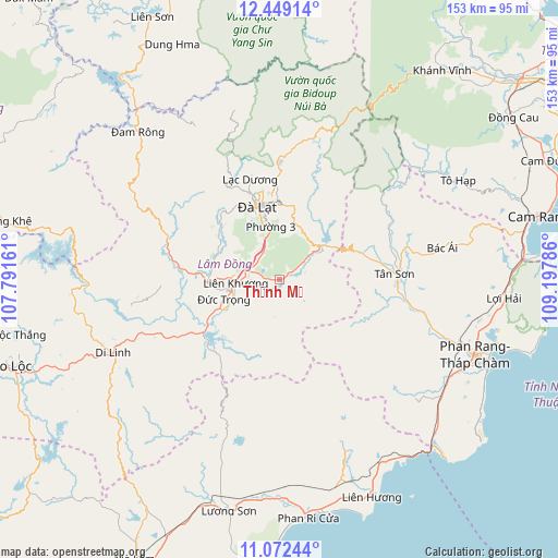
Thạnh Mỹ GPS coordinates[2]
11° 45' 41.94" North, 108° 29' 41.028" East
| Map corner | latitude | longitude |
|---|---|---|
| Upper-left | 12.44914°, | 107.79161° |
| Center: | 11.76165°, | 108.49473° |
| Lower-right: | 11.07244°, | 109.19786° |
| Map W x H: | 153.1×153.1 km | = 95.1×95.1mi |
| max Lat: | 23.27841° ⇑69% North |
| Thạnh Mỹ: | 11.76165° |
| min Lat: | ⇓31% South 8.65724° |
| min Long | Thạnh Mỹ | max Long |
| 102.4579° | 108.49473° | 112.72541° |
| W 91.8%⇐ | ⇒8.2% E |
Elevation
Elevation of Thạnh Mỹ is 1014 m = 3327 ft, and this is 884.5 m = 2902 ft above average elevation for this country.
| Max E: |
1592 m = 5223 ft | 1.5% |
| Thạnh Mỹ | 1014 m 3327 ft | |
| Avg. | 129.5 m = 425 ft | |
Min E: |
-1 m = -3 ft | 98.5% |
See also: Vietnam elevation on elevation.city.
Geographical zone
Thạnh Mỹ is located in North Torrid zone (between Equator and Tropic of Cancer). Distance of this Northern Tropic circle is 1298.1 km =806.6 mi to North.| Distance of | km | miles | from Thạnh Mỹ |
|---|---|---|---|
| North Pole | 8699.3 | 5405.5 | to North |
| Arctic Circle | 6093.4 | 3786.3 | to North |
| Tropic Cancer | 1298.1 | 806.6 | to North |
| Equator | 1307.8 | 812.6 | to South |


Nearby cities:
15 places around Thạnh Mỹ: (largest is in red/bold)
• Bác Ái
45.3 km =28.1 mi,  78°
78°
• Chợ Lầu
60.1 km =37.3 mi,  178°
178°
• Di Linh
49.8 km =30.9 mi,  246°
246°
• Khánh Hải
62.4 km =38.8 mi,  107°
107°
• Khánh Vĩnh
73.2 km =45.5 mi,  37°
37°
• Liên Hương
64.4 km =40 mi,  157°
157°
• Lạc Dương
28.2 km =17.5 mi,  343°
343°
• Lộc Thắng
73.3 km =45.5 mi,  258°
258°
• Phan Rang-Tháp Chàm
58.1 km =36.1 mi, 112°
• Phước Dân
54.1 km =33.6 mi,  118°
118°
• Tân Sơn
31.6 km =19.6 mi,  87°
87°
• Tô Hạp
56.4 km =35 mi,  61°
61°
• Ðà Lạt
21.3 km =13.2 mi, 344°
• Đinh Văn
27.6 km =17.1 mi,  275°
275°
• Đưc Trọng
13.5 km =8.4 mi, 257°
Sources, notices
• [Note1] Compared only with cities in Vietnam existing in our database
• [Src1] Map data: © OpenStreetMap contributors (CC-BY-SA)
• [Src2] Other city data from geonames.org with taken over terms of usage.
• [Src3] Geographical zone / Annual Mean Temperature by Robert A. Rohde @ Wikipedia
