Cam Ranh geodata
Cam Ranh (Khánh Hòa) is a populated place; located in Vietnam in Asia/Ho_Chi_Minh (GMT+7) time zone. With population of 146,771 people, there are 24 cities with bigger population in this country. Compared to other cities in Vietnam, 68% of cities are located further ↑North; 98.5% of cities are located further ←West and 51.5% of cities have lower elevation than Cam Ranh. Note1


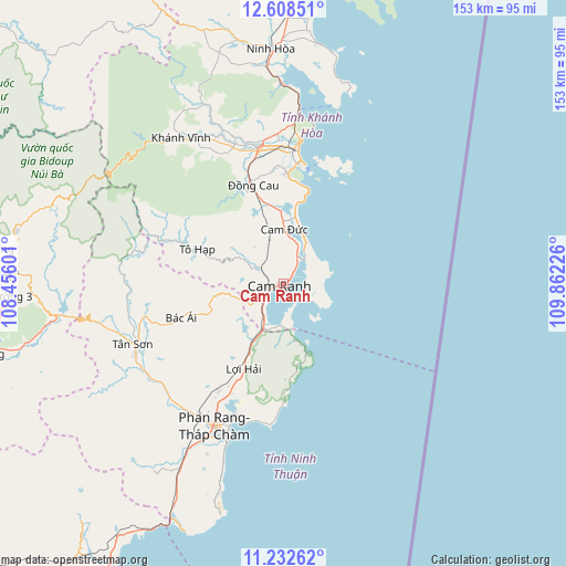
Cam Ranh GPS coordinates[2]
11° 55' 17.184" North, 109° 9' 32.868" East
| Map corner | latitude | longitude |
|---|---|---|
| Upper-left | 12.60851°, | 108.45601° |
| Center: | 11.92144°, | 109.15913° |
| Lower-right: | 11.23262°, | 109.86226° |
| Map W x H: | 153×153 km | = 95.1×95.1mi |
| max Lat: | 23.27841° ⇑68% North |
| Cam Ranh: | 11.92144° |
| min Lat: | ⇓32% South 8.65724° |
| min Long | Cam Ranh | max Long |
| 102.4579° | 109.15913° | 112.72541° |
| W 98.5%⇐ | ⇒1.5% E |
Elevation
Elevation of Cam Ranh is 15 m = 49 ft, and this is 114.5 m = 376 ft below average elevation for this country.
| Max E: |
1592 m = 5223 ft | 48.5% |
| Avg. | 129.5 m = 425 ft | |
| Cam Ranh | 15 m = 49 ft | |
Min E: |
-1 m = -3 ft | 51.5% |
See also: Cam Ranh elevation on elevation.city.
Geographical zone
Cam Ranh is located in North Torrid zone (between Equator and Tropic of Cancer). Distance of this Northern Tropic circle is 1280.4 km =795.6 mi to North.| Distance of | km | miles | from Cam Ranh |
|---|---|---|---|
| North Pole | 8681.5 | 5394.4 | to North |
| Arctic Circle | 6075.6 | 3775.2 | to North |
| Tropic Cancer | 1280.4 | 795.6 | to North |
| Equator | 1325.5 | 823.6 | to South |


Nearby cities:
15 places around Cam Ranh: (largest is in red/bold)
• Bác Ái
29.3 km =18.2 mi,  252°
252°
• Cam Lâm
14.7 km =9.1 mi,  0°
0°
• Diên Khánh
37.8 km =23.5 mi,  349°
349°
• Khánh Hải
38.9 km =24.2 mi,  199°
199°
• Khánh Vĩnh
48.8 km =30.3 mi,  325°
325°
• Lạc Dương
81 km =50.3 mi,  276°
276°
• Nha Trang
36.2 km =22.5 mi,  6°
6°
• Ninh Hòa
63.5 km =39.5 mi,  356°
356°
• Phan Rang-Tháp Chàm
43.8 km =27.2 mi,  205°
205°
• Phước Dân
50.5 km =31.4 mi, 209°
• Thạnh Mỹ
74.5 km =46.3 mi,  256°
256°
• Tân Sơn
43.9 km =27.3 mi, 248°
• Tô Hạp
24.7 km =15.3 mi,  292°
292°
• Vạn Giã
85.9 km =53.4 mi, 4°
• Ðà Lạt
78.1 km =48.5 mi,  272°
272°
Sources, notices
• [Note1] Compared only with cities in Vietnam existing in our database
• [Src1] Map data: © OpenStreetMap contributors (CC-BY-SA)
• [Src2] Other city data from geonames.org with taken over terms of usage.
• [Src3] Geographical zone / Annual Mean Temperature by Robert A. Rohde @ Wikipedia
