Ðà Lạt geodata
Ðà Lạt (Lâm Đồng) is a seat of a first-order administrative division; located in Vietnam in Asia/Ho_Chi_Minh (GMT+7) time zone. With population of 197,000 people, there are 13 cities with bigger population in this country. Compared to other cities in Vietnam, 67.9% of cities are located further ↑North; 91% of cities are located further ←West and 99.7% of cities have lower elevation than Ðà Lạt. Note1


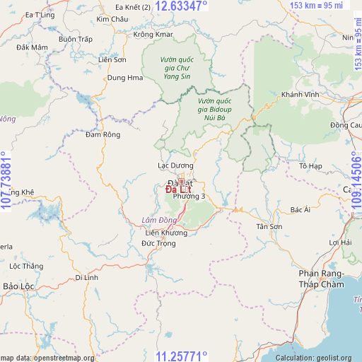
Ðà Lạt GPS coordinates[2]
11° 56' 47.256" North, 108° 26' 30.948" East
| Map corner | latitude | longitude |
|---|---|---|
| Upper-left | 12.63347°, | 107.73881° |
| Center: | 11.94646°, | 108.44193° |
| Lower-right: | 11.25771°, | 109.14506° |
| Map W x H: | 153×153 km | = 95.1×95.1mi |
| max Lat: | 23.27841° ⇑67.9% North |
| Ðà Lạt: | 11.94646° |
| min Lat: | ⇓32.1% South 8.65724° |
| min Long | Ðà Lạt | max Long |
| 102.4579° | 108.44193° | 112.72541° |
| W 91%⇐ | ⇒9% E |
Elevation
Elevation of Ðà Lạt is 1483 m = 4865 ft, and this is 1353.5 m = 4441 ft above average elevation for this country.
| Max E: |
1592 m = 5223 ft | 0.3% |
| Ðà Lạt | 1483 m 4865 ft | |
| Avg. | 129.5 m = 425 ft | |
Min E: |
-1 m = -3 ft | 99.7% |
See also: Ðà Lạt elevation on elevation.city.
Geographical zone
Ðà Lạt is located in North Torrid zone (between Equator and Tropic of Cancer). Distance of this Northern Tropic circle is 1277.6 km =793.9 mi to North.| Distance of | km | miles | from Ðà Lạt |
|---|---|---|---|
| North Pole | 8678.7 | 5392.7 | to North |
| Arctic Circle | 6072.9 | 3773.5 | to North |
| Tropic Cancer | 1277.6 | 793.9 | to North |
| Equator | 1328.3 | 825.4 | to South |


Nearby cities:
15 places around Ðà Lạt: (largest is in red/bold)
• Buôn Trấp
74.8 km =46.5 mi,  323°
323°
• Bác Ái
51.5 km =32 mi,  103°
103°
• Di Linh
56.8 km =35.3 mi,  224°
224°
• Khánh Vĩnh
62.7 km =39 mi,  53°
53°
• Krông Kmar
63.2 km =39.3 mi,  349°
349°
• Lạc Dương
6.9 km =4.3 mi,  338°
338°
• Lắk
59.1 km =36.7 mi,  330°
330°
• Lộc Thắng
74.9 km =46.5 mi,  241°
241°
• Phan Rang-Tháp Chàm
73.1 km =45.4 mi,  125°
125°
• Phước Dân
70.7 km =43.9 mi, 131°
• Thạnh Mỹ
21.3 km =13.2 mi,  164°
164°
• Tân Sơn
41.9 km =26 mi,  117°
117°
• Tô Hạp
55.5 km =34.5 mi,  83°
83°
• Đinh Văn
28 km =17.4 mi,  230°
230°
• Đưc Trọng
24.6 km =15.3 mi,  197°
197°
Sources, notices
• [Note1] Compared only with cities in Vietnam existing in our database
• [Src1] Map data: © OpenStreetMap contributors (CC-BY-SA)
• [Src2] Other city data from geonames.org with taken over terms of usage.
• [Src3] Geographical zone / Annual Mean Temperature by Robert A. Rohde @ Wikipedia
