Đưc Trọng geodata
Đưc Trọng (Lâm Đồng) is a seat of a second-order administrative division; located in Vietnam in Asia/Ho_Chi_Minh (GMT+7) time zone. With population of 161,232 people, there are 16 cities with bigger population in this country. Compared to other cities in Vietnam, 69.2% of cities are located further ↑North; 90.4% of cities are located further ←West and 97.9% of cities have lower elevation than Đưc Trọng. Note1


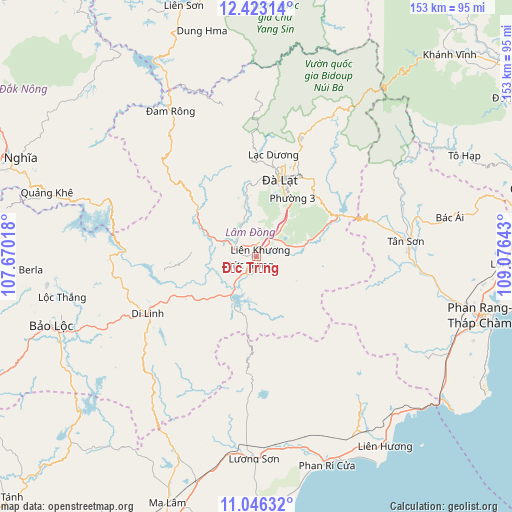
Đưc Trọng GPS coordinates[2]
11° 44' 8.124" North, 108° 22' 23.88" East
| Map corner | latitude | longitude |
|---|---|---|
| Upper-left | 12.42314°, | 107.67018° |
| Center: | 11.73559°, | 108.3733° |
| Lower-right: | 11.04632°, | 109.07643° |
| Map W x H: | 153.1×153.1 km | = 95.1×95.1mi |
| max Lat: | 23.27841° ⇑69.2% North |
| Đưc Trọng: | 11.73559° |
| min Lat: | ⇓30.8% South 8.65724° |
| min Long | Đưc Trọng | max Long |
| 102.4579° | 108.3733° | 112.72541° |
| W 90.4%⇐ | ⇒9.6% E |
Elevation
Elevation of Đưc Trọng is 939 m = 3081 ft, and this is 809.5 m = 2656 ft above average elevation for this country.
| Max E: |
1592 m = 5223 ft | 2.1% |
| Đưc Trọng | 939 m 3081 ft | |
| Avg. | 129.5 m = 425 ft | |
Min E: |
-1 m = -3 ft | 97.9% |
See also: Đưc Trọng elevation on elevation.city.
Geographical zone
Đưc Trọng is located in North Torrid zone (between Equator and Tropic of Cancer). Distance of this Northern Tropic circle is 1301 km =808.4 mi to North.| Distance of | km | miles | from Đưc Trọng |
|---|---|---|---|
| North Pole | 8702.2 | 5407.3 | to North |
| Arctic Circle | 6096.3 | 3788.1 | to North |
| Tropic Cancer | 1301 | 808.4 | to North |
| Equator | 1304.9 | 810.8 | to South |


Nearby cities:
15 places around Đưc Trọng: (largest is in red/bold)
• Bác Ái
58.9 km =36.6 mi,  78°
78°
• Bảo Lộc
65 km =40.4 mi,  251°
251°
• Chợ Lầu
59 km =36.7 mi,  165°
165°
• Di Linh
36.6 km =22.7 mi,  242°
242°
• Khánh Hải
74.4 km =46.2 mi,  102°
102°
• Liên Hương
68.2 km =42.4 mi,  145°
145°
• Lạc Dương
30.3 km =18.8 mi,  9°
9°
• Lộc Thắng
59.8 km =37.2 mi,  258°
258°
• Phan Rang-Tháp Chàm
69.7 km =43.3 mi,  105°
105°
• Phước Dân
64.9 km =40.3 mi, 110°
• Thạnh Mỹ
13.5 km =8.4 mi, 77°
• Tân Sơn
45 km =28 mi, 84°
• Tô Hạp
69.4 km =43.1 mi,  64°
64°
• Ðà Lạt
24.6 km =15.3 mi,  17°
17°
• Đinh Văn
15.3 km =9.5 mi,  291°
291°
Sources, notices
• [Note1] Compared only with cities in Vietnam existing in our database
• [Src1] Map data: © OpenStreetMap contributors (CC-BY-SA)
• [Src2] Other city data from geonames.org with taken over terms of usage.
• [Src3] Geographical zone / Annual Mean Temperature by Robert A. Rohde @ Wikipedia
