Kwang Binh geodata
Kwang Binh (Quảng Bình) is a seat of a first-order administrative division; located in Vietnam in Asia/Ho_Chi_Minh (GMT+7) time zone. With population of 31,040 people, there are 75 cities with bigger population in this country. Compared to other cities in Vietnam, 51.4% of cities are located further ↓South; 66.4% of cities are located further ←West and 65.4% of cities have higher elevation than Kwang Binh. Note1


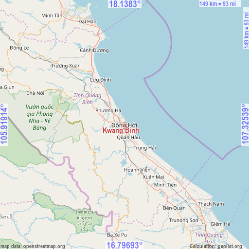
Kwang Binh GPS coordinates[2]
17° 28' 7.86" North, 106° 37' 20.136" East
| Map corner | latitude | longitude |
|---|---|---|
| Upper-left | 18.1383°, | 105.91914° |
| Center: | 17.46885°, | 106.62226° |
| Lower-right: | 16.79693°, | 107.32539° |
| Map W x H: | 149.1×149.1 km | = 92.6×92.6mi |
| max Lat: | 23.27841° ⇑48.6% North |
| Kwang Binh: | 17.46885° |
| min Lat: | ⇓51.4% South 8.65724° |
| min Long | Kwang Binh | max Long |
| 102.4579° | 106.62226° | 112.72541° |
| W 66.4%⇐ | ⇒33.6% E |
Elevation
Elevation of Kwang Binh is 9 m = 30 ft, and this is 120.5 m = 395 ft below average elevation for this country.
| Max E: |
1592 m = 5223 ft | 65.4% |
| Avg. | 129.5 m = 425 ft | |
| Kwang Binh | 9 m = 30 ft | |
Min E: |
-1 m = -3 ft | 34.6% |
See also: Vietnam elevation on elevation.city.
Geographical zone
Kwang Binh is located in North Torrid zone (between Equator and Tropic of Cancer). Distance of this Northern Tropic circle is 663.6 km =412.3 mi to North.| Distance of | km | miles | from Kwang Binh |
|---|---|---|---|
| North Pole | 8064.7 | 5011.2 | to North |
| Arctic Circle | 5458.8 | 3391.9 | to North |
| Tropic Cancer | 663.6 | 412.3 | to North |
| Equator | 1942.4 | 1207 | to South |


Nearby cities:
15 places around Kwang Binh: (largest is in red/bold)
• Ba Đồn
38 km =23.6 mi,  326°
326°
• Cam Lộ
83.4 km =51.8 mi,  151°
151°
• Cẩm Xuyên
108.9 km =67.7 mi,  322°
322°
• Gio Linh
77.9 km =48.4 mi,  140°
140°
• Hoàn Lão
15.9 km =9.9 mi, 323°
• Hồ Xá
60.3 km =37.5 mi, 137°
• Khe Sanh
94.3 km =58.6 mi,  172°
172°
• Kiến Giang
32.6 km =20.3 mi, 146°
• Krông Klang
91.2 km =56.7 mi,  161°
161°
• Kỳ Anh
74.4 km =46.2 mi, 332°
• Oui Dat
78.5 km =48.8 mi,  298°
298°
• Quán Hàu
7.4 km =4.6 mi, 164°
• Ái Tử
96.9 km =60.2 mi, 143°
• Ðông Hà
88.6 km =55.1 mi, 145°
• Đồng Lê
78.3 km =48.7 mi,  306°
306°
In other languages:
- In Spanish: Dong Hoi
- In France: Đồng Hới
- In German: Dong Hoi
- In Italian: Dong Hoi
- In Russian: Донгхой
Sources, notices
• [Note1] Compared only with cities in Vietnam existing in our database
• [Src1] Map data: © OpenStreetMap contributors (CC-BY-SA)
• [Src2] Other city data from geonames.org with taken over terms of usage.
• [Src3] Geographical zone / Annual Mean Temperature by Robert A. Rohde @ Wikipedia
