Ad Durayhimī geodata
Ad Durayhimī (Al Hudaydah) is a seat of a second-order administrative division; located in Yemen in Asia/Aden (GMT+3) time zone. In our database, there are 51 cities with bigger population. Compared to other cities in Yemen, 56.5% of cities are located further ↑North; 97.7% of cities are located further →East and 92.2% of cities have higher elevation than Ad Durayhimī. Note1


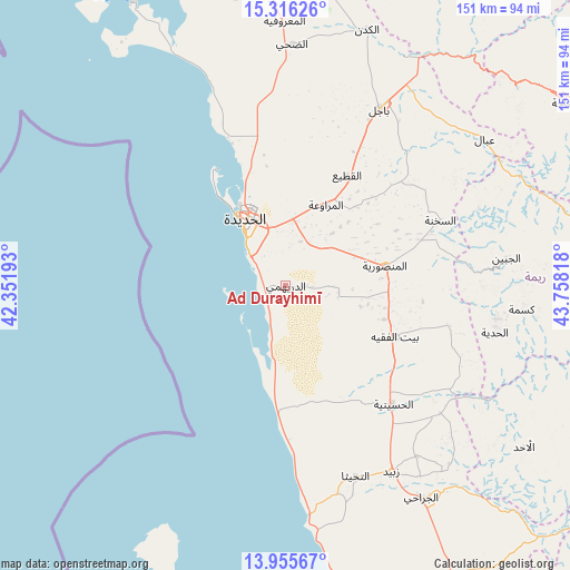
Ad Durayhimī GPS coordinates[2]
14° 38' 13.272" North, 43° 3' 18.18" East
| Map corner | latitude | longitude |
|---|---|---|
| Upper-left | 15.31626°, | 42.35193° |
| Center: | 14.63702°, | 43.05505° |
| Lower-right: | 13.95567°, | 43.75818° |
| Map W x H: | 151.3×151.3 km | = 94×94mi |
| max Lat: | 17.76999° ⇑56.5% North |
| Ad Durayhimī: | 14.63702° |
| min Lat: | ⇓43.5% South 12.18576° |
| min Long | Ad Durayhimī | max Long |
| 42.67107° | 43.05505° | 54.01895° |
| W 2.3%⇐ | ⇒97.7% E |
Elevation
Elevation of Ad Durayhimī is 25 m = 82 ft, and this is 1279.8 m = 4199 ft below average elevation for this country.
| Max E: |
2791 m = 9157 ft | 92.2% |
| Avg. | 1304.8 m = 4281 ft | |
| Ad Durayhimī | 25 m = 82 ft | |
Min E: |
4 m = 13 ft | 7.8% |
See also: Yemen elevation on elevation.city.
Geographical zone
Ad Durayhimī is located in North Torrid zone (between Equator and Tropic of Cancer). Distance of this Northern Tropic circle is 978.4 km =607.9 mi to North.| Distance of | km | miles | from Ad Durayhimī |
|---|---|---|---|
| North Pole | 8379.6 | 5206.8 | to North |
| Arctic Circle | 5773.7 | 3587.6 | to North |
| Tropic Cancer | 978.4 | 607.9 | to North |
| Equator | 1627.5 | 1011.3 | to South |


Nearby cities:
15 places around Ad Durayhimī: (largest is in red/bold)
• Al Jabīn
59 km =36.7 mi,  82°
82°
• Al Manşūrīyah
26.8 km =16.7 mi, 78°
• Al Marāwi‘ah
24 km =14.9 mi,  26°
26°
• Al Ḩadīyah
56.8 km =35.3 mi,  102°
102°
• Al Ḩudaydah
20.9 km =13 mi,  328°
328°
• As Sukhnah
44.6 km =27.7 mi,  66°
66°
• At Tuḩaytā’
53.7 km =33.4 mi,  159°
159°
• Bayt al Faqīh
31.9 km =19.8 mi,  114°
114°
• Bājil
53.1 km =33 mi, 28°
• Dhahi
64.3 km =40 mi,  1°
1°
• Kusmah
62.9 km =39.1 mi, 95°
• Markaz Bilād aţ Ţa‘ām
56.2 km =34.9 mi, 67°
• Riqāb
52 km =32.3 mi,  57°
57°
• Zabīd
56.6 km =35.2 mi,  150°
150°
• ‘Ubāl
65.5 km =40.7 mi,  53°
53°
Sources, notices
• [Note1] Compared only with cities in Yemen existing in our database
• [Src1] Map data: © OpenStreetMap contributors (CC-BY-SA)
• [Src2] Other city data from geonames.org with taken over terms of usage.
• [Src3] Geographical zone / Annual Mean Temperature by Robert A. Rohde @ Wikipedia
