Al Manşūrīyah geodata
Al Manşūrīyah (Al Hudaydah) is a seat of a second-order administrative division; located in Yemen in Asia/Aden (GMT+3) time zone. In our database, there are 51 cities with bigger population. Compared to other cities in Yemen, 54.9% of cities are located further ↑North; 92.9% of cities are located further →East and 86.7% of cities have higher elevation than Al Manşūrīyah. Note1


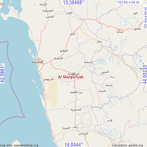
Al Manşūrīyah GPS coordinates[2]
14° 41' 8.16" North, 43° 17' 57.192" East
| Map corner | latitude | longitude |
|---|---|---|
| Upper-left | 15.36468°, | 42.5961° |
| Center: | 14.6856°, | 43.29922° |
| Lower-right: | 14.0044°, | 44.00235° |
| Map W x H: | 151.2×151.3 km | = 94×94mi |
| max Lat: | 17.76999° ⇑54.9% North |
| Al Manşūrīyah: | 14.6856° |
| min Lat: | ⇓45.1% South 12.18576° |
| min Long | Al Manşūrīya | max Long |
| 42.67107° | 43.29922° | 54.01895° |
| W 7.1%⇐ | ⇒92.9% E |
Elevation
Elevation of Al Manşūrīyah is 122 m = 400 ft, and this is 1182.8 m = 3881 ft below average elevation for this country.
| Max E: |
2791 m = 9157 ft | 86.7% |
| Avg. | 1304.8 m = 4281 ft | |
| Al Manşūrīyah | 122 m = 400 ft | |
Min E: |
4 m = 13 ft | 13.3% |
See also: Yemen elevation on elevation.city.
Geographical zone
Al Manşūrīyah is located in North Torrid zone (between Equator and Tropic of Cancer). Distance of this Northern Tropic circle is 973 km =604.6 mi to North.| Distance of | km | miles | from Al Manşūrīyah |
|---|---|---|---|
| North Pole | 8374.2 | 5203.5 | to North |
| Arctic Circle | 5768.3 | 3584.3 | to North |
| Tropic Cancer | 973 | 604.6 | to North |
| Equator | 1632.9 | 1014.6 | to South |


Nearby cities:
15 places around Al Manşūrīyah: (largest is in red/bold)
• Ad Durayhimī
26.8 km =16.7 mi,  258°
258°
• Al Jabīn
32.3 km =20.1 mi,  86°
86°
• Al Marāwi‘ah
22.5 km =14 mi,  315°
315°
• Al Ḩadīyah
34.1 km =21.2 mi,  121°
121°
• Al Ḩudaydah
39.1 km =24.3 mi,  288°
288°
• As Sukhnah
19 km =11.8 mi,  50°
50°
• Aḑ Ḑil‘
55.8 km =34.7 mi, 91°
• Bayt al Faqīh
19 km =11.8 mi,  171°
171°
• Bājil
41.5 km =25.8 mi,  358°
358°
• Kusmah
38.1 km =23.7 mi,  107°
107°
• Markaz Bilād aţ Ţa‘ām
30.4 km =18.9 mi,  57°
57°
• Matwaḩ
56.2 km =34.9 mi,  40°
40°
• Riqāb
28.5 km =17.7 mi, 38°
• Zabīd
54.6 km =33.9 mi,  178°
178°
• ‘Ubāl
42.7 km =26.5 mi, 38°
Sources, notices
• [Note1] Compared only with cities in Yemen existing in our database
• [Src1] Map data: © OpenStreetMap contributors (CC-BY-SA)
• [Src2] Other city data from geonames.org with taken over terms of usage.
• [Src3] Geographical zone / Annual Mean Temperature by Robert A. Rohde @ Wikipedia
