Dhamār geodata
Dhamār is a seat of a first-order administrative division; located in Yemen in Asia/Aden (GMT+3) time zone. With population of 160,114 people, there are 6 cities with bigger population in this country. Compared to other cities in Yemen, 57.8% of cities are located further ↑North; 51.3% of cities are located further ←West and 93.2% of cities have lower elevation than Dhamār. Note1


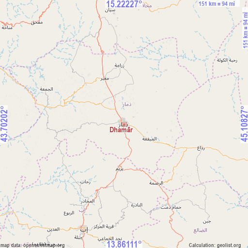
Dhamār GPS coordinates[2]
14° 32' 33.864" North, 44° 24' 18.504" East
| Map corner | latitude | longitude |
|---|---|---|
| Upper-left | 15.22227°, | 43.70202° |
| Center: | 14.54274°, | 44.40514° |
| Lower-right: | 13.86111°, | 45.10827° |
| Map W x H: | 151.3×151.4 km | = 94×94.1mi |
| max Lat: | 17.76999° ⇑57.8% North |
| Dhamār: | 14.54274° |
| min Lat: | ⇓42.2% South 12.18576° |
| min Long | Dhamār | max Long |
| 42.67107° | 44.40514° | 54.01895° |
| W 51.3%⇐ | ⇒48.7% E |
Elevation
Elevation of Dhamār is 2421 m = 7943 ft, and this is 1116.2 m = 3662 ft above average elevation for this country.
| Max E: |
2791 m = 9157 ft | 6.8% |
| Dhamār | 2421 m 7943 ft | |
| Avg. | 1304.8 m = 4281 ft | |
Min E: |
4 m = 13 ft | 93.2% |
See also: Dhamār elevation on elevation.city.
Geographical zone
Dhamār is located in North Torrid zone (between Equator and Tropic of Cancer). Distance of this Northern Tropic circle is 988.9 km =614.5 mi to North.| Distance of | km | miles | from Dhamār |
|---|---|---|---|
| North Pole | 8390.1 | 5213.4 | to North |
| Arctic Circle | 5784.2 | 3594.1 | to North |
| Tropic Cancer | 988.9 | 614.5 | to North |
| Equator | 1617 | 1004.8 | to South |


Nearby cities:
15 places around Dhamār: (largest is in red/bold)
• Al Mayfa’ah
17.8 km =11.1 mi,  119°
119°
• Al Qurayshīyah
48.4 km =30.1 mi,  94°
94°
• Ar Raḑmah
40.9 km =25.4 mi,  151°
151°
• As Saddah
46.8 km =29.1 mi,  177°
177°
• Ma‘bar
30.4 km =18.9 mi,  336°
336°
• Milāḩ
43.4 km =27 mi,  108°
108°
• Radā‘
48.6 km =30.2 mi, 106°
• Riḩāb
42.1 km =26.2 mi,  213°
213°
• Sūq ar Rubū‘
42.1 km =26.2 mi,  265°
265°
• Yarīm
27.4 km =17 mi,  186°
186°
• Zakhim
40.8 km =25.4 mi,  132°
132°
• Zarājah
36.2 km =22.5 mi,  355°
355°
• Ḑawrān ad Daydah
30.6 km =19 mi,  315°
315°
• Ḑubāh
30.1 km =18.7 mi,  258°
258°
• Ḩammām ‘Alī
30.8 km =19.1 mi,  295°
295°
Sources, notices
• [Note1] Compared only with cities in Yemen existing in our database
• [Src1] Map data: © OpenStreetMap contributors (CC-BY-SA)
• [Src2] Other city data from geonames.org with taken over terms of usage.
• [Src3] Geographical zone / Annual Mean Temperature by Robert A. Rohde @ Wikipedia
