Al Mayfa’ah geodata
Al Mayfa’ah (Dhamār) is a seat of a second-order administrative division; located in Yemen in Asia/Aden (GMT+3) time zone. In our database, there are 51 cities with bigger population. Compared to other cities in Yemen, 61% of cities are located further ↑North; 54.9% of cities are located further ←West and 94.8% of cities have lower elevation than Al Mayfa’ah. Note1


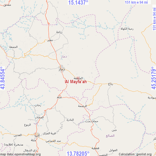
Al Mayfa’ah GPS coordinates[2]
14° 27' 50.112" North, 44° 32' 55.176" East
| Map corner | latitude | longitude |
|---|---|---|
| Upper-left | 15.1437°, | 43.84554° |
| Center: | 14.46392°, | 44.54866° |
| Lower-right: | 13.78205°, | 45.25179° |
| Map W x H: | 151.4×151.4 km | = 94.1×94.1mi |
| max Lat: | 17.76999° ⇑61% North |
| Al Mayfa’ah: | 14.46392° |
| min Lat: | ⇓39% South 12.18576° |
| min Long | Al Mayfa’ah | max Long |
| 42.67107° | 44.54866° | 54.01895° |
| W 54.9%⇐ | ⇒45.1% E |
Elevation
Elevation of Al Mayfa’ah is 2459 m = 8068 ft, and this is 1154.2 m = 3787 ft above average elevation for this country.
| Max E: |
2791 m = 9157 ft | 5.2% |
| Al Mayfa’ah | 2459 m 8068 ft | |
| Avg. | 1304.8 m = 4281 ft | |
Min E: |
4 m = 13 ft | 94.8% |
See also: Yemen elevation on elevation.city.
Geographical zone
Al Mayfa’ah is located in North Torrid zone (between Equator and Tropic of Cancer). Distance of this Northern Tropic circle is 997.7 km =619.9 mi to North.| Distance of | km | miles | from Al Mayfa’ah |
|---|---|---|---|
| North Pole | 8398.8 | 5218.8 | to North |
| Arctic Circle | 5792.9 | 3599.5 | to North |
| Tropic Cancer | 997.7 | 619.9 | to North |
| Equator | 1608.2 | 999.3 | to South |


Nearby cities:
15 places around Al Mayfa’ah: (largest is in red/bold)
• Al Qurayshīyah
33.3 km =20.7 mi,  80°
80°
• Al ‘Aqabah
33.4 km =20.8 mi,  129°
129°
• An Nādirah
41.6 km =25.8 mi,  190°
190°
• Ar Raḑmah
27.5 km =17.1 mi,  171°
171°
• As Saddah
40.4 km =25.1 mi,  199°
199°
• Dhamār
17.8 km =11.1 mi,  299°
299°
• Ma‘bar
45.8 km =28.5 mi,  323°
323°
• Milāḩ
26.1 km =16.2 mi,  101°
101°
• Radā‘
31.5 km =19.6 mi, 99°
• Riḩāb
46.9 km =29.1 mi,  235°
235°
• Yarīm
26 km =16.2 mi,  224°
224°
• Zakhim
23.8 km =14.8 mi,  141°
141°
• Ḑawrān ad Daydah
47.9 km =29.8 mi,  309°
309°
• Ḑubāh
45.1 km =28 mi,  273°
273°
• Ḩammām Damt
43.6 km =27.1 mi,  162°
162°
Sources, notices
• [Note1] Compared only with cities in Yemen existing in our database
• [Src1] Map data: © OpenStreetMap contributors (CC-BY-SA)
• [Src2] Other city data from geonames.org with taken over terms of usage.
• [Src3] Geographical zone / Annual Mean Temperature by Robert A. Rohde @ Wikipedia
