Zakhim geodata
Zakhim (Al Bayda) is a seat of a second-order administrative division; located in Yemen in Asia/Aden (GMT+3) time zone. In our database, there are 51 cities with bigger population. Compared to other cities in Yemen, 67.2% of cities are located further ↑North; 57.5% of cities are located further ←West and 98.7% of cities have lower elevation than Zakhim. Note1


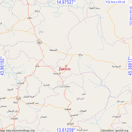
Zakhim GPS coordinates[2]
14° 17' 41.856" North, 44° 41' 6.144" East
| Map corner | latitude | longitude |
|---|---|---|
| Upper-left | 14.97527°, | 43.98192° |
| Center: | 14.29496°, | 44.68504° |
| Lower-right: | 13.61259°, | 45.38817° |
| Map W x H: | 151.5×151.5 km | = 94.1×94.1mi |
| max Lat: | 17.76999° ⇑67.2% North |
| Zakhim: | 14.29496° |
| min Lat: | ⇓32.8% South 12.18576° |
| min Long | Zakhim | max Long |
| 42.67107° | 44.68504° | 54.01895° |
| W 57.5%⇐ | ⇒42.5% E |
Elevation
Elevation of Zakhim is 2629 m = 8625 ft, and this is 1324.2 m = 4344 ft above average elevation for this country.
| Max E: |
2791 m = 9157 ft | 1.3% |
| Zakhim | 2629 m 8625 ft | |
| Avg. | 1304.8 m = 4281 ft | |
Min E: |
4 m = 13 ft | 98.7% |
See also: Yemen elevation on elevation.city.
Geographical zone
Zakhim is located in North Torrid zone (between Equator and Tropic of Cancer). Distance of this Northern Tropic circle is 1016.5 km =631.6 mi to North.| Distance of | km | miles | from Zakhim |
|---|---|---|---|
| North Pole | 8417.6 | 5230.5 | to North |
| Arctic Circle | 5811.7 | 3611.2 | to North |
| Tropic Cancer | 1016.5 | 631.6 | to North |
| Equator | 1589.5 | 987.7 | to South |


Nearby cities:
15 places around Zakhim: (largest is in red/bold)
• Al Mayfa’ah
23.8 km =14.8 mi,  321°
321°
• Al Qurayshīyah
30.2 km =18.8 mi,  36°
36°
• Al ‘Aqabah
11.3 km =7 mi,  103°
103°
• An Nādirah
31.6 km =19.6 mi,  225°
225°
• Ar Raḑmah
13.5 km =8.4 mi, 231°
• Ar Riḑā’ī
44 km =27.3 mi, 225°
• As Saddah
34.3 km =21.3 mi,  235°
235°
• Ash Sharyah
37 km =23 mi,  79°
79°
• Dhamār
40.8 km =25.4 mi,  312°
312°
• Juban
37.6 km =23.4 mi,  147°
147°
• Milāḩ
17.3 km =10.7 mi, 38°
• Qa‘ţabah
49 km =30.4 mi,  177°
177°
• Radā‘
21.1 km =13.1 mi,  50°
50°
• Yarīm
33.1 km =20.6 mi,  270°
270°
• Ḩammām Damt
22.8 km =14.2 mi, 184°
Sources, notices
• [Note1] Compared only with cities in Yemen existing in our database
• [Src1] Map data: © OpenStreetMap contributors (CC-BY-SA)
• [Src2] Other city data from geonames.org with taken over terms of usage.
• [Src3] Geographical zone / Annual Mean Temperature by Robert A. Rohde @ Wikipedia
