Al ‘Inān geodata
Al ‘Inān (Al Jawf) is a seat of a second-order administrative division; located in Yemen in Asia/Aden (GMT+3) time zone. With population of 100 people, there are 45 cities with bigger population in this country. Compared to other cities in Yemen, 93.5% of cities are located further ↓South; 51% of cities are located further →East and 81.2% of cities have lower elevation than Al ‘Inān. Note1


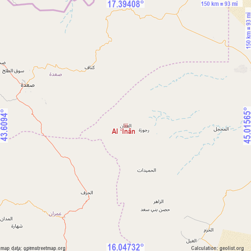
Al ‘Inān GPS coordinates[2]
16° 43' 18.804" North, 44° 18' 45.072" East
| Map corner | latitude | longitude |
|---|---|---|
| Upper-left | 17.39408°, | 43.6094° |
| Center: | 16.72189°, | 44.31252° |
| Lower-right: | 16.04732°, | 45.01565° |
| Map W x H: | 149.7×149.7 km | = 93×93mi |
| max Lat: | 17.76999° ⇑6.5% North |
| Al ‘Inān: | 16.72189° |
| min Lat: | ⇓93.5% South 12.18576° |
| min Long | Al ‘Inān | max Long |
| 42.67107° | 44.31252° | 54.01895° |
| W 49%⇐ | ⇒51% E |
Elevation
Elevation of Al ‘Inān is 2131 m = 6991 ft, and this is 826.2 m = 2711 ft above average elevation for this country.
| Max E: |
2791 m = 9157 ft | 18.8% |
| Al ‘Inān | 2131 m 6991 ft | |
| Avg. | 1304.8 m = 4281 ft | |
Min E: |
4 m = 13 ft | 81.2% |
See also: Yemen elevation on elevation.city.
Geographical zone
Al ‘Inān is located in North Torrid zone (between Equator and Tropic of Cancer). Distance of this Northern Tropic circle is 746.6 km =463.9 mi to North.| Distance of | km | miles | from Al ‘Inān |
|---|---|---|---|
| North Pole | 8147.8 | 5062.8 | to North |
| Arctic Circle | 5541.9 | 3443.6 | to North |
| Tropic Cancer | 746.6 | 463.9 | to North |
| Equator | 1859.3 | 1155.3 | to South |


Nearby cities:
15 places around Al ‘Inān: (largest is in red/bold)
• Al Khirāb
18.8 km =11.7 mi,  187°
187°
• Al Matūn
61.9 km =38.5 mi,  152°
152°
• Al Maşlūb
68.6 km =42.6 mi, 150°
• Al Maḩjal
57 km =35.4 mi,  91°
91°
• Al Ḩarf
46.1 km =28.6 mi,  210°
210°
• Al Ḩashwah
20.9 km =13 mi,  349°
349°
• Al Ḩumaydāt
29.2 km =18.1 mi, 154°
• Al ‘Ashshah
71.1 km =44.2 mi,  223°
223°
• Ash Shawātī
53.7 km =33.4 mi,  277°
277°
• Az Zāhir
49 km =30.4 mi,  156°
156°
• Kitāf
40.7 km =25.3 mi,  327°
327°
• Rajūzah
11.1 km =6.9 mi,  102°
102°
• Sa'dah
63.2 km =39.3 mi,  292°
292°
• Ḩişn Banī Sa‘d
52.9 km =32.9 mi, 160°
• Ḩūth
65.7 km =40.8 mi, 213°
Sources, notices
• [Note1] Compared only with cities in Yemen existing in our database
• [Src1] Map data: © OpenStreetMap contributors (CC-BY-SA)
• [Src2] Other city data from geonames.org with taken over terms of usage.
• [Src3] Geographical zone / Annual Mean Temperature by Robert A. Rohde @ Wikipedia
