Ḩūth geodata
Ḩūth (Omran) is a seat of a second-order administrative division; located in Yemen in Asia/Aden (GMT+3) time zone. In our database, there are 51 cities with bigger population. Compared to other cities in Yemen, 88.6% of cities are located further ↓South; 66.6% of cities are located further →East and 68.8% of cities have lower elevation than Ḩūth. Note1


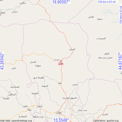
Ḩūth GPS coordinates[2]
16° 13' 52.104" North, 43° 58' 6.744" East
| Map corner | latitude | longitude |
|---|---|---|
| Upper-left | 16.90507°, | 43.26542° |
| Center: | 16.23114°, | 43.96854° |
| Lower-right: | 15.5549°, | 44.67167° |
| Map W x H: | 150.1×150.1 km | = 93.3×93.3mi |
| max Lat: | 17.76999° ⇑11.4% North |
| Ḩūth: | 16.23114° |
| min Lat: | ⇓88.6% South 12.18576° |
| min Long | Ḩūth | max Long |
| 42.67107° | 43.96854° | 54.01895° |
| W 33.4%⇐ | ⇒66.6% E |
Elevation
Elevation of Ḩūth is 1889 m = 6198 ft, and this is 584.2 m = 1917 ft above average elevation for this country.
| Max E: |
2791 m = 9157 ft | 31.2% |
| Ḩūth | 1889 m 6198 ft | |
| Avg. | 1304.8 m = 4281 ft | |
Min E: |
4 m = 13 ft | 68.8% |
See also: Yemen elevation on elevation.city.
Geographical zone
Ḩūth is located in North Torrid zone (between Equator and Tropic of Cancer). Distance of this Northern Tropic circle is 801.2 km =497.8 mi to North.| Distance of | km | miles | from Ḩūth |
|---|---|---|---|
| North Pole | 8202.3 | 5096.7 | to North |
| Arctic Circle | 5596.4 | 3477.4 | to North |
| Tropic Cancer | 801.2 | 497.8 | to North |
| Equator | 1804.7 | 1121.4 | to South |


Nearby cities:
15 places around Ḩūth: (largest is in red/bold)
• Al Jamīmah
46.3 km =28.8 mi,  239°
239°
• Al Khirāb
49.7 km =30.9 mi,  43°
43°
• Al Madān
34.7 km =21.6 mi,  268°
268°
• Al Qaflah
23.5 km =14.6 mi,  294°
294°
• Al Ḩarf
19.9 km =12.4 mi, 42°
• Al ‘Ashshah
12.5 km =7.8 mi,  283°
283°
• As Sūdah
36.3 km =22.6 mi,  213°
213°
• As Sūq al Jadīd
46.3 km =28.8 mi,  167°
167°
• Aş Şarārah
49.7 km =30.9 mi,  192°
192°
• Dhaybīn
33 km =20.5 mi,  148°
148°
• Khamir
27.1 km =16.8 mi,  183°
183°
• Raydah
47 km =29.2 mi, 170°
• Shahārat al Ghīs
28.9 km =18 mi,  259°
259°
• Şuwayr
38.7 km =24 mi, 261°
• Ḩabūr
34.4 km =21.4 mi,  234°
234°
Sources, notices
• [Note1] Compared only with cities in Yemen existing in our database
• [Src1] Map data: © OpenStreetMap contributors (CC-BY-SA)
• [Src2] Other city data from geonames.org with taken over terms of usage.
• [Src3] Geographical zone / Annual Mean Temperature by Robert A. Rohde @ Wikipedia
