Al Maḩjal geodata
Al Maḩjal (Al Jawf) is a seat of a second-order administrative division; located in Yemen in Asia/Aden (GMT+3) time zone. In our database, there are 51 cities with bigger population. Compared to other cities in Yemen, 93.2% of cities are located further ↓South; 62% of cities are located further ←West and 55.2% of cities have lower elevation than Al Maḩjal. Note1


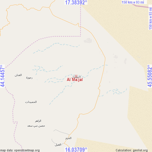
Al Maḩjal GPS coordinates[2]
16° 42' 42.084" North, 44° 50' 51.684" East
| Map corner | latitude | longitude |
|---|---|---|
| Upper-left | 17.38392°, | 44.14457° |
| Center: | 16.71169°, | 44.84769° |
| Lower-right: | 16.03709°, | 45.55082° |
| Map W x H: | 149.8×149.8 km | = 93.1×93.1mi |
| max Lat: | 17.76999° ⇑6.8% North |
| Al Maḩjal: | 16.71169° |
| min Lat: | ⇓93.2% South 12.18576° |
| min Long | Al Maḩjal | max Long |
| 42.67107° | 44.84769° | 54.01895° |
| W 62%⇐ | ⇒38% E |
Elevation
Elevation of Al Maḩjal is 1436 m = 4711 ft, and this is 131.2 m = 430 ft above average elevation for this country.
| Max E: |
2791 m = 9157 ft | 44.8% |
| Al Maḩjal | 1436 m 4711 ft | |
| Avg. | 1304.8 m = 4281 ft | |
Min E: |
4 m = 13 ft | 55.2% |
See also: Yemen elevation on elevation.city.
Geographical zone
Al Maḩjal is located in North Torrid zone (between Equator and Tropic of Cancer). Distance of this Northern Tropic circle is 747.8 km =464.7 mi to North.| Distance of | km | miles | from Al Maḩjal |
|---|---|---|---|
| North Pole | 8148.9 | 5063.5 | to North |
| Arctic Circle | 5543 | 3444.3 | to North |
| Tropic Cancer | 747.8 | 464.7 | to North |
| Equator | 1858.2 | 1154.6 | to South |


Nearby cities:
15 places around Al Maḩjal: (largest is in red/bold)
• Al Ghayl
69.5 km =43.2 mi,  194°
194°
• Al Khirāb
61.9 km =38.5 mi,  253°
253°
• Al Matūn
60.4 km =37.5 mi,  207°
207°
• Al Maşlūb
63.4 km =39.4 mi,  201°
201°
• Al Ḩarf
89.1 km =55.4 mi,  244°
244°
• Al Ḩashwah
64.6 km =40.1 mi,  289°
289°
• Al Ḩazm
61.4 km =38.2 mi, 187°
• Al Ḩumaydāt
51.2 km =31.8 mi, 240°
• Al ‘Inān
57 km =35.4 mi,  271°
271°
• Ar Rawḑ
72.4 km =45 mi,  183°
183°
• Az Zāhir
57.8 km =35.9 mi,  220°
220°
• Kitāf
86.3 km =53.6 mi, 294°
• Majzar
96.1 km =59.7 mi, 184°
• Rajūzah
46.1 km =28.6 mi, 268°
• Ḩişn Banī Sa‘d
62.8 km =39 mi, 218°
Sources, notices
• [Note1] Compared only with cities in Yemen existing in our database
• [Src1] Map data: © OpenStreetMap contributors (CC-BY-SA)
• [Src2] Other city data from geonames.org with taken over terms of usage.
• [Src3] Geographical zone / Annual Mean Temperature by Robert A. Rohde @ Wikipedia
