Az Zāhir geodata
Az Zāhir (Al Jawf) is a seat of a second-order administrative division; located in Yemen in Asia/Aden (GMT+3) time zone. In our database, there are 51 cities with bigger population. Compared to other cities in Yemen, 89.9% of cities are located further ↓South; 54.5% of cities are located further ←West and 55.8% of cities have higher elevation than Az Zāhir. Note1


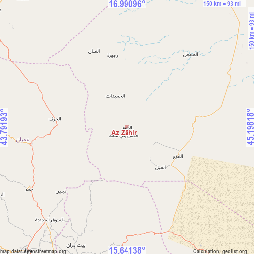
Az Zāhir GPS coordinates[2]
16° 19' 2.388" North, 44° 29' 42.18" East
| Map corner | latitude | longitude |
|---|---|---|
| Upper-left | 16.99096°, | 43.79193° |
| Center: | 16.31733°, | 44.49505° |
| Lower-right: | 15.64138°, | 45.19818° |
| Map W x H: | 150.1×150.1 km | = 93.3×93.3mi |
| max Lat: | 17.76999° ⇑10.1% North |
| Az Zāhir: | 16.31733° |
| min Lat: | ⇓89.9% South 12.18576° |
| min Long | Az Zāhir | max Long |
| 42.67107° | 44.49505° | 54.01895° |
| W 54.5%⇐ | ⇒45.5% E |
Elevation
Elevation of Az Zāhir is 1206 m = 3957 ft, and this is 98.8 m = 324 ft below average elevation for this country.
| Max E: |
2791 m = 9157 ft | 55.8% |
| Avg. | 1304.8 m = 4281 ft | |
| Az Zāhir | 1206 m = 3957 ft | |
Min E: |
4 m = 13 ft | 44.2% |
See also: Yemen elevation on elevation.city.
Geographical zone
Az Zāhir is located in North Torrid zone (between Equator and Tropic of Cancer). Distance of this Northern Tropic circle is 791.6 km =491.9 mi to North.| Distance of | km | miles | from Az Zāhir |
|---|---|---|---|
| North Pole | 8192.7 | 5090.7 | to North |
| Arctic Circle | 5586.9 | 3471.5 | to North |
| Tropic Cancer | 791.6 | 491.9 | to North |
| Equator | 1814.3 | 1127.4 | to South |


Nearby cities:
15 places around Az Zāhir: (largest is in red/bold)
• Al Ghayl
30.5 km =19 mi,  139°
139°
• Al Khirāb
34.2 km =21.3 mi,  320°
320°
• Al Matūn
13.6 km =8.5 mi, 135°
• Al Maşlūb
20.5 km =12.7 mi, 136°
• Al Maḩjal
57.8 km =35.9 mi,  40°
40°
• Al Ḩarf
43.1 km =26.8 mi,  276°
276°
• Al Ḩazm
34.6 km =21.5 mi,  119°
119°
• Al Ḩumaydāt
19.9 km =12.4 mi,  339°
339°
• Al ‘Inān
49 km =30.4 mi, 336°
• Ar Rawḑ
44.1 km =27.4 mi,  130°
130°
• Dhaybīn
54.4 km =33.8 mi,  225°
225°
• Majzar
60 km =37.3 mi,  150°
150°
• Rajūzah
43.5 km =27 mi,  348°
348°
• Ḩişn Banī Sa‘d
5.3 km =3.3 mi,  201°
201°
• Ḩūth
57 km =35.4 mi,  260°
260°
Sources, notices
• [Note1] Compared only with cities in Yemen existing in our database
• [Src1] Map data: © OpenStreetMap contributors (CC-BY-SA)
• [Src2] Other city data from geonames.org with taken over terms of usage.
• [Src3] Geographical zone / Annual Mean Temperature by Robert A. Rohde @ Wikipedia
