Al Ḩarf geodata
Al Ḩarf (Omran) is a seat of a second-order administrative division; located in Yemen in Asia/Aden (GMT+3) time zone. In our database, there are 51 cities with bigger population. Compared to other cities in Yemen, 90.9% of cities are located further ↓South; 61.4% of cities are located further →East and 59.7% of cities have lower elevation than Al Ḩarf. Note1


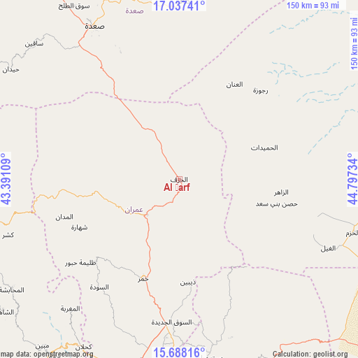
Al Ḩarf GPS coordinates[2]
16° 21' 50.22" North, 44° 5' 39.156" East
| Map corner | latitude | longitude |
|---|---|---|
| Upper-left | 17.03741°, | 43.39109° |
| Center: | 16.36395°, | 44.09421° |
| Lower-right: | 15.68816°, | 44.79734° |
| Map W x H: | 150×150 km | = 93.2×93.2mi |
| max Lat: | 17.76999° ⇑9.1% North |
| Al Ḩarf: | 16.36395° |
| min Lat: | ⇓90.9% South 12.18576° |
| min Long | Al Ḩarf | max Long |
| 42.67107° | 44.09421° | 54.01895° |
| W 38.6%⇐ | ⇒61.4% E |
Elevation
Elevation of Al Ḩarf is 1570 m = 5151 ft, and this is 265.2 m = 870 ft above average elevation for this country.
| Max E: |
2791 m = 9157 ft | 40.3% |
| Al Ḩarf | 1570 m 5151 ft | |
| Avg. | 1304.8 m = 4281 ft | |
Min E: |
4 m = 13 ft | 59.7% |
See also: Yemen elevation on elevation.city.
Geographical zone
Al Ḩarf is located in North Torrid zone (between Equator and Tropic of Cancer). Distance of this Northern Tropic circle is 786.4 km =488.6 mi to North.| Distance of | km | miles | from Al Ḩarf |
|---|---|---|---|
| North Pole | 8187.6 | 5087.5 | to North |
| Arctic Circle | 5581.7 | 3468.3 | to North |
| Tropic Cancer | 786.4 | 488.6 | to North |
| Equator | 1819.5 | 1130.6 | to South |


Nearby cities:
15 places around Al Ḩarf: (largest is in red/bold)
• Al Khirāb
29.8 km =18.5 mi,  44°
44°
• Al Madān
50.5 km =31.4 mi,  252°
252°
• Al Matūn
54.4 km =33.8 mi,  105°
105°
• Al Qaflah
35.2 km =21.9 mi,  261°
261°
• Al Ḩumaydāt
38.2 km =23.7 mi,  69°
69°
• Al ‘Ashshah
28.2 km =17.5 mi,  244°
244°
• Al ‘Inān
46.1 km =28.6 mi,  30°
30°
• Az Zāhir
43.1 km =26.8 mi,  96°
96°
• Dhaybīn
43.2 km =26.8 mi,  175°
175°
• Khamir
44.4 km =27.6 mi,  199°
199°
• Rajūzah
50.7 km =31.5 mi, 42°
• Shahārat al Ghīs
46.4 km =28.8 mi, 244°
• Ḩabūr
54 km =33.6 mi,  229°
229°
• Ḩişn Banī Sa‘d
42.1 km =26.2 mi, 103°
• Ḩūth
19.9 km =12.4 mi,  222°
222°
Sources, notices
• [Note1] Compared only with cities in Yemen existing in our database
• [Src1] Map data: © OpenStreetMap contributors (CC-BY-SA)
• [Src2] Other city data from geonames.org with taken over terms of usage.
• [Src3] Geographical zone / Annual Mean Temperature by Robert A. Rohde @ Wikipedia
