Ma'rib geodata
Ma'rib (Ma’rib) is a seat of a first-order administrative division; located in Yemen in Asia/Aden (GMT+3) time zone. With population of 16,794 people, there are 22 cities with bigger population in this country. Compared to other cities in Yemen, 64% of cities are located further ↓South; 72.4% of cities are located further ←West and 62% of cities have higher elevation than Ma'rib. Note1


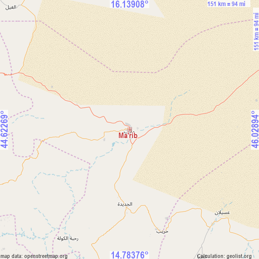
Ma'rib GPS coordinates[2]
15° 27' 45.108" North, 45° 19' 32.916" East
| Map corner | latitude | longitude |
|---|---|---|
| Upper-left | 16.13908°, | 44.62269° |
| Center: | 15.46253°, | 45.32581° |
| Lower-right: | 14.78376°, | 46.02894° |
| Map W x H: | 150.7×150.7 km | = 93.6×93.6mi |
| max Lat: | 17.76999° ⇑36% North |
| Ma'rib: | 15.46253° |
| min Lat: | ⇓64% South 12.18576° |
| min Long | Ma'rib | max Long |
| 42.67107° | 45.32581° | 54.01895° |
| W 72.4%⇐ | ⇒27.6% E |
Elevation
Elevation of Ma'rib is 1095 m = 3593 ft, and this is 209.8 m = 688 ft below average elevation for this country.
| Max E: |
2791 m = 9157 ft | 62% |
| Avg. | 1304.8 m = 4281 ft | |
| Ma'rib | 1095 m = 3593 ft | |
Min E: |
4 m = 13 ft | 38% |
See also: Yemen elevation on elevation.city.
Geographical zone
Ma'rib is located in North Torrid zone (between Equator and Tropic of Cancer). Distance of this Northern Tropic circle is 886.6 km =550.9 mi to North.| Distance of | km | miles | from Ma'rib |
|---|---|---|---|
| North Pole | 8287.8 | 5149.8 | to North |
| Arctic Circle | 5681.9 | 3530.6 | to North |
| Tropic Cancer | 886.6 | 550.9 | to North |
| Equator | 1719.3 | 1068.3 | to South |


Nearby cities:
15 places around Ma'rib: (largest is in red/bold)
• Al Ḩajab
71.3 km =44.3 mi,  162°
162°
• Al Ḩarjah
70.8 km =44 mi,  272°
272°
• Al Ḩuşūn
4.6 km =2.9 mi,  73°
73°
• Al ‘Amūd
83.4 km =51.8 mi,  188°
188°
• Ar Rawḑ
86.5 km =53.7 mi,  320°
320°
• Asdās
42.7 km =26.5 mi, 322°
• Bayḩān
84.8 km =52.7 mi,  150°
150°
• Bidbadah
67.2 km =41.8 mi, 266°
• Judaydah
43.2 km =26.8 mi,  183°
183°
• Madghil
34.1 km =21.2 mi,  296°
296°
• Majzar
73 km =45.4 mi,  306°
306°
• Raḩabah
72.7 km =45.2 mi,  209°
209°
• Sūq Şirwāḩ
32.9 km =20.4 mi, 267°
• Ḩarīb
62 km =38.5 mi, 162°
• ‘Usaylān
72.1 km =44.8 mi,  131°
131°
Sources, notices
• [Note1] Compared only with cities in Yemen existing in our database
• [Src1] Map data: © OpenStreetMap contributors (CC-BY-SA)
• [Src2] Other city data from geonames.org with taken over terms of usage.
• [Src3] Geographical zone / Annual Mean Temperature by Robert A. Rohde @ Wikipedia
