Bayḩān geodata
Bayḩān (Shabwah) is a seat of a second-order administrative division; located in Yemen in Asia/Aden (GMT+3) time zone. In our database, there are 51 cities with bigger population. Compared to other cities in Yemen, 51.3% of cities are located further ↑North; 76.9% of cities are located further ←West and 60.7% of cities have higher elevation than Bayḩān. Note1


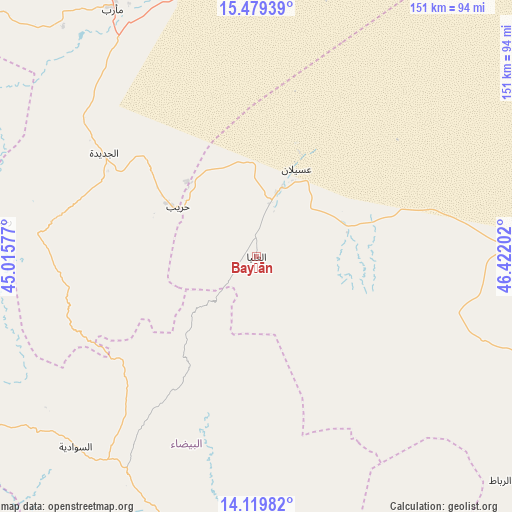
Bayḩān GPS coordinates[2]
14° 48' 2.412" North, 45° 43' 8.004" East
| Map corner | latitude | longitude |
|---|---|---|
| Upper-left | 15.47939°, | 45.01577° |
| Center: | 14.80067°, | 45.71889° |
| Lower-right: | 14.11982°, | 46.42202° |
| Map W x H: | 151.2×151.2 km | = 94×94mi |
| max Lat: | 17.76999° ⇑51.3% North |
| Bayḩān: | 14.80067° |
| min Lat: | ⇓48.7% South 12.18576° |
| min Long | Bayḩān | max Long |
| 42.67107° | 45.71889° | 54.01895° |
| W 76.9%⇐ | ⇒23.1% E |
Elevation
Elevation of Bayḩān is 1127 m = 3698 ft, and this is 177.8 m = 583 ft below average elevation for this country.
| Max E: |
2791 m = 9157 ft | 60.7% |
| Avg. | 1304.8 m = 4281 ft | |
| Bayḩān | 1127 m = 3698 ft | |
Min E: |
4 m = 13 ft | 39.3% |
See also: Yemen elevation on elevation.city.
Geographical zone
Bayḩān is located in North Torrid zone (between Equator and Tropic of Cancer). Distance of this Northern Tropic circle is 960.2 km =596.6 mi to North.| Distance of | km | miles | from Bayḩān |
|---|---|---|---|
| North Pole | 8361.4 | 5195.5 | to North |
| Arctic Circle | 5755.5 | 3576.3 | to North |
| Tropic Cancer | 960.2 | 596.6 | to North |
| Equator | 1645.7 | 1022.6 | to South |


Nearby cities:
15 places around Bayḩān: (largest is in red/bold)
• Al Aqţa‘
42.4 km =26.3 mi,  248°
248°
• Al Ghaylah
27 km =16.8 mi,  212°
212°
• Al Ḩajab
21.2 km =13.2 mi,  285°
285°
• Al Ḩazm
17.1 km =10.6 mi,  223°
223°
• Al ‘Amūd
55.8 km =34.7 mi,  260°
260°
• Al ‘Āqir
33.1 km =20.6 mi,  141°
141°
• An Najd
62 km =38.5 mi,  227°
227°
• As Sawādīyah
77.1 km =47.9 mi, 223°
• Jayshān
78.6 km =48.8 mi, 140°
• Judaydah
54.4 km =33.8 mi,  304°
304°
• Khawrah
62.3 km =38.7 mi,  131°
131°
• Maswarah
50.8 km =31.6 mi,  179°
179°
• Āl Ma‘ūdah
74.7 km =46.4 mi, 208°
• Ḩarīb
27.3 km =17 mi, 302°
• ‘Usaylān
28.3 km =17.6 mi,  24°
24°
Sources, notices
• [Note1] Compared only with cities in Yemen existing in our database
• [Src1] Map data: © OpenStreetMap contributors (CC-BY-SA)
• [Src2] Other city data from geonames.org with taken over terms of usage.
• [Src3] Geographical zone / Annual Mean Temperature by Robert A. Rohde @ Wikipedia
