Madghil geodata
Madghil (Ma’rib) is a seat of a second-order administrative division; located in Yemen in Asia/Aden (GMT+3) time zone. In our database, there are 51 cities with bigger population. Compared to other cities in Yemen, 69.2% of cities are located further ↓South; 68.2% of cities are located further ←West and 57.5% of cities have higher elevation than Madghil. Note1


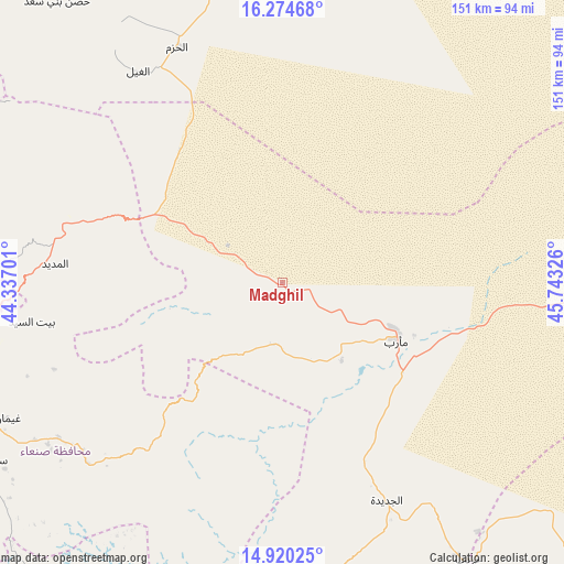
Madghil GPS coordinates[2]
15° 35' 54.888" North, 45° 2' 24.468" East
| Map corner | latitude | longitude |
|---|---|---|
| Upper-left | 16.27468°, | 44.33701° |
| Center: | 15.59858°, | 45.04013° |
| Lower-right: | 14.92025°, | 45.74326° |
| Map W x H: | 150.6×150.6 km | = 93.6×93.6mi |
| max Lat: | 17.76999° ⇑30.8% North |
| Madghil: | 15.59858° |
| min Lat: | ⇓69.2% South 12.18576° |
| min Long | Madghil | max Long |
| 42.67107° | 45.04013° | 54.01895° |
| W 68.2%⇐ | ⇒31.8% E |
Elevation
Elevation of Madghil is 1197 m = 3927 ft, and this is 107.8 m = 354 ft below average elevation for this country.
| Max E: |
2791 m = 9157 ft | 57.5% |
| Avg. | 1304.8 m = 4281 ft | |
| Madghil | 1197 m = 3927 ft | |
Min E: |
4 m = 13 ft | 42.5% |
See also: Yemen elevation on elevation.city.
Geographical zone
Madghil is located in North Torrid zone (between Equator and Tropic of Cancer). Distance of this Northern Tropic circle is 871.5 km =541.5 mi to North.| Distance of | km | miles | from Madghil |
|---|---|---|---|
| North Pole | 8272.7 | 5140.4 | to North |
| Arctic Circle | 5666.8 | 3521.2 | to North |
| Tropic Cancer | 871.5 | 541.5 | to North |
| Equator | 1734.4 | 1077.7 | to South |


Nearby cities:
15 places around Madghil: (largest is in red/bold)
• Al Ghayl
68.5 km =42.6 mi,  325°
325°
• Al Madīd
60.9 km =37.8 mi,  274°
274°
• Al Maşlūb
78.6 km =48.8 mi, 325°
• Al Ḩarjah
41.9 km =26 mi,  253°
253°
• Al Ḩazm
68.9 km =42.8 mi,  335°
335°
• Al Ḩuşūn
37.7 km =23.4 mi,  111°
111°
• Ar Rawḑ
57 km =35.4 mi, 334°
• Asdās
19.1 km =11.9 mi,  13°
13°
• Bidbadah
41.2 km =25.6 mi,  242°
242°
• Jiḩānah
72.7 km =45.2 mi, 235°
• Judaydah
64.5 km =40.1 mi,  154°
154°
• Ma'rib
34.1 km =21.2 mi,  116°
116°
• Majzar
39.8 km =24.7 mi,  314°
314°
• Raḩabah
78.4 km =48.7 mi,  184°
184°
• Sūq Şirwāḩ
16.8 km =10.4 mi,  187°
187°
Sources, notices
• [Note1] Compared only with cities in Yemen existing in our database
• [Src1] Map data: © OpenStreetMap contributors (CC-BY-SA)
• [Src2] Other city data from geonames.org with taken over terms of usage.
• [Src3] Geographical zone / Annual Mean Temperature by Robert A. Rohde @ Wikipedia
