Al Qurayshīyah geodata
Al Qurayshīyah (Al Bayda) is a seat of a second-order administrative division; located in Yemen in Asia/Aden (GMT+3) time zone. In our database, there are 51 cities with bigger population. Compared to other cities in Yemen, 59.4% of cities are located further ↑North; 63% of cities are located further ←West and 84.1% of cities have lower elevation than Al Qurayshīyah. Note1


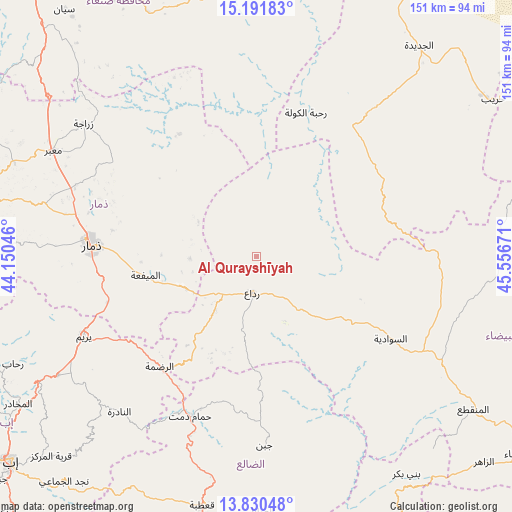
Al Qurayshīyah GPS coordinates[2]
14° 30' 43.92" North, 44° 51' 12.888" East
| Map corner | latitude | longitude |
|---|---|---|
| Upper-left | 15.19183°, | 44.15046° |
| Center: | 14.5122°, | 44.85358° |
| Lower-right: | 13.83048°, | 45.55671° |
| Map W x H: | 151.4×151.4 km | = 94.1×94.1mi |
| max Lat: | 17.76999° ⇑59.4% North |
| Al Qurayshīyah: | 14.5122° |
| min Lat: | ⇓40.6% South 12.18576° |
| min Long | Al Qurayshīyah | max Long |
| 42.67107° | 44.85358° | 54.01895° |
| W 63%⇐ | ⇒37% E |
Elevation
Elevation of Al Qurayshīyah is 2169 m = 7116 ft, and this is 864.2 m = 2835 ft above average elevation for this country.
| Max E: |
2791 m = 9157 ft | 15.9% |
| Al Qurayshīyah | 2169 m 7116 ft | |
| Avg. | 1304.8 m = 4281 ft | |
Min E: |
4 m = 13 ft | 84.1% |
See also: Yemen elevation on elevation.city.
Geographical zone
Al Qurayshīyah is located in North Torrid zone (between Equator and Tropic of Cancer). Distance of this Northern Tropic circle is 992.3 km =616.6 mi to North.| Distance of | km | miles | from Al Qurayshīyah |
|---|---|---|---|
| North Pole | 8393.5 | 5215.5 | to North |
| Arctic Circle | 5787.6 | 3596.2 | to North |
| Tropic Cancer | 992.3 | 616.6 | to North |
| Equator | 1613.6 | 1002.6 | to South |


Nearby cities:
15 places around Al Qurayshīyah: (largest is in red/bold)
• Al Aqţa‘
56.1 km =34.9 mi,  72°
72°
• Al Mayfa’ah
33.3 km =20.7 mi,  260°
260°
• Al ‘Amūd
44.5 km =27.7 mi,  58°
58°
• Al ‘Aqabah
27.7 km =17.2 mi,  195°
195°
• An Najd
48.7 km =30.3 mi,  101°
101°
• Ar Raḑmah
43.4 km =27 mi,  221°
221°
• As Sawādīyah
46 km =28.6 mi,  120°
120°
• Ash Sharyah
25.1 km =15.6 mi,  133°
133°
• Dhamār
48.4 km =30.1 mi,  274°
274°
• Juban
55.7 km =34.6 mi,  177°
177°
• Milāḩ
12.9 km =8 mi,  214°
214°
• Radā‘
10.9 km =6.8 mi,  189°
189°
• Raḩabah
45 km =28 mi,  18°
18°
• Zakhim
30.2 km =18.8 mi, 216°
• Ḩammām Damt
50.9 km =31.6 mi, 202°
Sources, notices
• [Note1] Compared only with cities in Yemen existing in our database
• [Src1] Map data: © OpenStreetMap contributors (CC-BY-SA)
• [Src2] Other city data from geonames.org with taken over terms of usage.
• [Src3] Geographical zone / Annual Mean Temperature by Robert A. Rohde @ Wikipedia
