Radā‘ geodata
Radā‘ (Al Bayda) is a seat of a second-order administrative division; located in Yemen in Asia/Aden (GMT+3) time zone. In our database, there are 51 cities with bigger population. Compared to other cities in Yemen, 62.7% of cities are located further ↑North; 61.7% of cities are located further ←West and 80.8% of cities have lower elevation than Radā‘. Note1


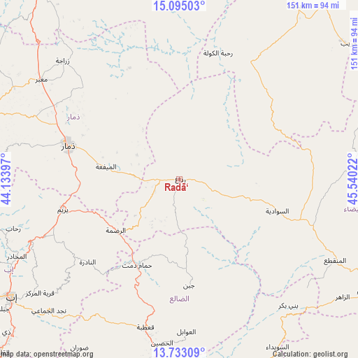
Radā‘ GPS coordinates[2]
14° 24' 54.36" North, 44° 50' 13.524" East
| Map corner | latitude | longitude |
|---|---|---|
| Upper-left | 15.09503°, | 44.13397° |
| Center: | 14.4151°, | 44.83709° |
| Lower-right: | 13.73309°, | 45.54022° |
| Map W x H: | 151.4×151.4 km | = 94.1×94.1mi |
| max Lat: | 17.76999° ⇑62.7% North |
| Radā‘: | 14.4151° |
| min Lat: | ⇓37.3% South 12.18576° |
| min Long | Radā‘ | max Long |
| 42.67107° | 44.83709° | 54.01895° |
| W 61.7%⇐ | ⇒38.3% E |
Elevation
Elevation of Radā‘ is 2125 m = 6972 ft, and this is 820.2 m = 2691 ft above average elevation for this country.
| Max E: |
2791 m = 9157 ft | 19.2% |
| Radā‘ | 2125 m 6972 ft | |
| Avg. | 1304.8 m = 4281 ft | |
Min E: |
4 m = 13 ft | 80.8% |
See also: Yemen elevation on elevation.city.
Geographical zone
Radā‘ is located in North Torrid zone (between Equator and Tropic of Cancer). Distance of this Northern Tropic circle is 1003.1 km =623.3 mi to North.| Distance of | km | miles | from Radā‘ |
|---|---|---|---|
| North Pole | 8404.3 | 5222.2 | to North |
| Arctic Circle | 5798.4 | 3603 | to North |
| Tropic Cancer | 1003.1 | 623.3 | to North |
| Equator | 1602.8 | 995.9 | to South |


Nearby cities:
15 places around Radā‘: (largest is in red/bold)
• Al Mayfa’ah
31.5 km =19.6 mi,  279°
279°
• Al Qurayshīyah
10.9 km =6.8 mi,  9°
9°
• Al ‘Amūd
52.3 km =32.5 mi,  49°
49°
• Al ‘Aqabah
16.8 km =10.4 mi,  198°
198°
• An Najd
49.4 km =30.7 mi,  89°
89°
• An Nādirah
52.7 km =32.7 mi,  227°
227°
• Ar Raḑmah
34.6 km =21.5 mi, 231°
• As Sawādīyah
43.3 km =26.9 mi,  107°
107°
• Ash Sharyah
21 km =13 mi, 108°
• Dhamār
48.6 km =30.2 mi,  286°
286°
• Juban
45 km =28 mi,  174°
174°
• Milāḩ
5.5 km =3.4 mi,  271°
271°
• Yarīm
51.1 km =31.8 mi,  255°
255°
• Zakhim
21.1 km =13.1 mi, 230°
• Ḩammām Damt
40.4 km =25.1 mi,  206°
206°
Sources, notices
• [Note1] Compared only with cities in Yemen existing in our database
• [Src1] Map data: © OpenStreetMap contributors (CC-BY-SA)
• [Src2] Other city data from geonames.org with taken over terms of usage.
• [Src3] Geographical zone / Annual Mean Temperature by Robert A. Rohde @ Wikipedia
