Ash Shaţţ geodata
Ash Shaţţ (Laḩij) is a seat of a second-order administrative division; located in Yemen in Asia/Aden (GMT+3) time zone. In our database, there are 51 cities with bigger population. Compared to other cities in Yemen, 96.4% of cities are located further ↑North; 63% of cities are located further →East and 83.4% of cities have higher elevation than Ash Shaţţ. Note1


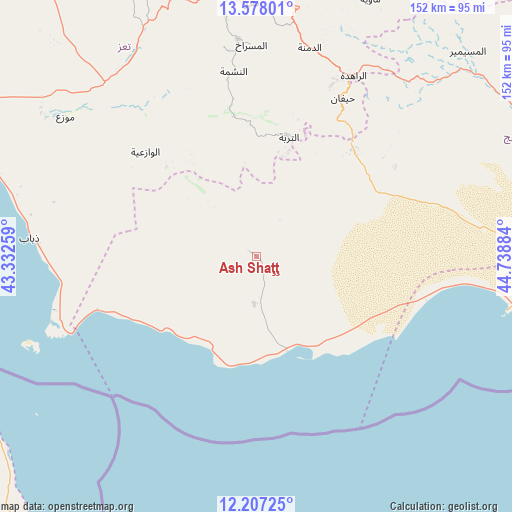
Ash Shaţţ GPS coordinates[2]
12° 53' 36.852" North, 44° 2' 8.556" East
| Map corner | latitude | longitude |
|---|---|---|
| Upper-left | 13.57801°, | 43.33259° |
| Center: | 12.89357°, | 44.03571° |
| Lower-right: | 12.20725°, | 44.73884° |
| Map W x H: | 152.4×152.4 km | = 94.7×94.7mi |
| max Lat: | 17.76999° ⇑96.4% North |
| Ash Shaţţ: | 12.89357° |
| min Lat: | ⇓3.6% South 12.18576° |
| min Long | Ash Shaţţ | max Long |
| 42.67107° | 44.03571° | 54.01895° |
| W 37%⇐ | ⇒63% E |
Elevation
Elevation of Ash Shaţţ is 237 m = 778 ft, and this is 1067.8 m = 3503 ft below average elevation for this country.
| Max E: |
2791 m = 9157 ft | 83.4% |
| Avg. | 1304.8 m = 4281 ft | |
| Ash Shaţţ | 237 m = 778 ft | |
Min E: |
4 m = 13 ft | 16.6% |
See also: Yemen elevation on elevation.city.
Geographical zone
Ash Shaţţ is located in North Torrid zone (between Equator and Tropic of Cancer). Distance of this Northern Tropic circle is 1172.3 km =728.4 mi to North.| Distance of | km | miles | from Ash Shaţţ |
|---|---|---|---|
| North Pole | 8573.4 | 5327.3 | to North |
| Arctic Circle | 5967.5 | 3708 | to North |
| Tropic Cancer | 1172.3 | 728.4 | to North |
| Equator | 1433.6 | 890.8 | to South |


Nearby cities:
15 places around Ash Shaţţ: (largest is in red/bold)
• Ad Dimnah
64.3 km =40 mi,  14°
14°
• Al Masālīyah
71.1 km =44.2 mi,  356°
356°
• Al Misrākh
63.1 km =39.2 mi, 358°
• Al Nashmah
55.7 km =34.6 mi,  352°
352°
• Al ‘Ayn
48.9 km =30.4 mi, 7°
• Ash Shuqayrah
38 km =23.6 mi,  314°
314°
• At Turbah
36.8 km =22.9 mi,  15°
15°
• Aş Şalw
52.2 km =32.4 mi, 22°
• Dhubāb
68 km =42.3 mi,  274°
274°
• Mawza‘
70.6 km =43.9 mi, 306°
• Yufrus
63.2 km =39.3 mi, 351°
• Ţawr al Bāḩah
42.9 km =26.7 mi,  41°
41°
• Ḩadādah
40.6 km =25.2 mi, 39°
• Ḩawrah
52.9 km =32.9 mi, 13°
• Ḩayfān
54.1 km =33.6 mi,  29°
29°
Sources, notices
• [Note1] Compared only with cities in Yemen existing in our database
• [Src1] Map data: © OpenStreetMap contributors (CC-BY-SA)
• [Src2] Other city data from geonames.org with taken over terms of usage.
• [Src3] Geographical zone / Annual Mean Temperature by Robert A. Rohde @ Wikipedia
