Al Ḩayfah geodata
Al Ḩayfah (Sanaa) is a seat of a second-order administrative division; located in Yemen in Asia/Aden (GMT+3) time zone. In our database, there are 51 cities with bigger population. Compared to other cities in Yemen, 74.4% of cities are located further ↓South; 54.2% of cities are located further →East and 92.9% of cities have lower elevation than Al Ḩayfah. Note1


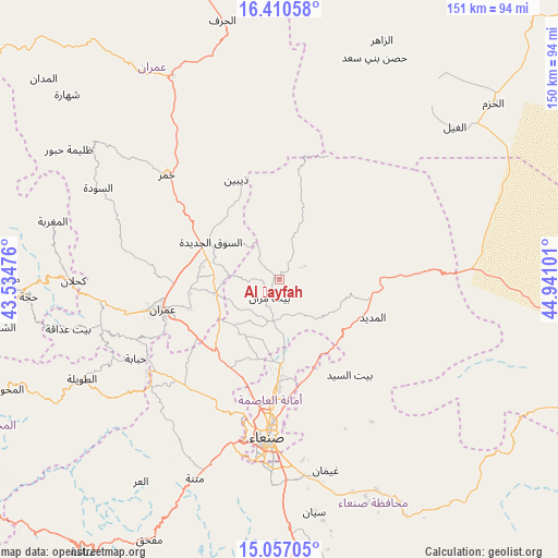
Al Ḩayfah GPS coordinates[2]
15° 44' 5.784" North, 44° 14' 16.368" East
| Map corner | latitude | longitude |
|---|---|---|
| Upper-left | 16.41058°, | 43.53476° |
| Center: | 15.73494°, | 44.23788° |
| Lower-right: | 15.05705°, | 44.94101° |
| Map W x H: | 150.5×150.5 km | = 93.5×93.5mi |
| max Lat: | 17.76999° ⇑25.6% North |
| Al Ḩayfah: | 15.73494° |
| min Lat: | ⇓74.4% South 12.18576° |
| min Long | Al Ḩayfah | max Long |
| 42.67107° | 44.23788° | 54.01895° |
| W 45.8%⇐ | ⇒54.2% E |
Elevation
Elevation of Al Ḩayfah is 2415 m = 7923 ft, and this is 1110.2 m = 3642 ft above average elevation for this country.
| Max E: |
2791 m = 9157 ft | 7.1% |
| Al Ḩayfah | 2415 m 7923 ft | |
| Avg. | 1304.8 m = 4281 ft | |
Min E: |
4 m = 13 ft | 92.9% |
See also: Yemen elevation on elevation.city.
Geographical zone
Al Ḩayfah is located in North Torrid zone (between Equator and Tropic of Cancer). Distance of this Northern Tropic circle is 856.4 km =532.1 mi to North.| Distance of | km | miles | from Al Ḩayfah |
|---|---|---|---|
| North Pole | 8257.5 | 5131 | to North |
| Arctic Circle | 5651.6 | 3511.7 | to North |
| Tropic Cancer | 856.4 | 532.1 | to North |
| Equator | 1749.6 | 1087.2 | to South |


Nearby cities:
15 places around Al Ḩayfah: (largest is in red/bold)
• Al Khāniq
26.5 km =16.5 mi,  193°
193°
• Al Madīd
27.1 km =16.8 mi,  111°
111°
• Ar Rawḑah
33.7 km =20.9 mi,  182°
182°
• As Sūq al Jadīd
21.3 km =13.2 mi,  298°
298°
• Aş Şarārah
39.9 km =24.8 mi,  279°
279°
• Bayt Marrān
5.8 km =3.6 mi,  216°
216°
• Dhaybīn
29.3 km =18.2 mi,  336°
336°
• Jadder Cemetery
30.5 km =19 mi, 192°
• Khamir
41.4 km =25.7 mi,  312°
312°
• Qaryat al Qābil
33.8 km =21 mi,  200°
200°
• Raydah
22.9 km =14.2 mi,  292°
292°
• Sanaa
42.4 km =26.3 mi, 184°
• Saḩḩab
27.2 km =16.9 mi,  237°
237°
• Shibām
43.6 km =27.1 mi,  234°
234°
• ‘Amrān
32.6 km =20.3 mi,  255°
255°
Sources, notices
• [Note1] Compared only with cities in Yemen existing in our database
• [Src1] Map data: © OpenStreetMap contributors (CC-BY-SA)
• [Src2] Other city data from geonames.org with taken over terms of usage.
• [Src3] Geographical zone / Annual Mean Temperature by Robert A. Rohde @ Wikipedia
