Al Bāţinah geodata
Al Bāţinah (Ḩaḑramawt) is a seat of a second-order administrative division; located in Yemen in Asia/Aden (GMT+3) time zone. In our database, there are 51 cities with bigger population. Compared to other cities in Yemen, 65.6% of cities are located further ↓South; 89.6% of cities are located further ←West and 67.2% of cities have higher elevation than Al Bāţinah. Note1


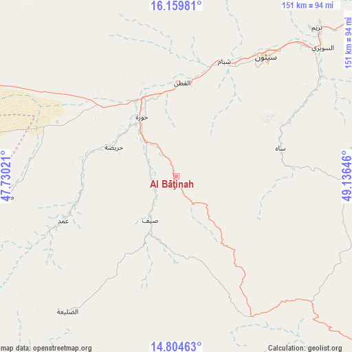
Al Bāţinah GPS coordinates[2]
15° 28' 59.988" North, 48° 25' 59.988" East
| Map corner | latitude | longitude |
|---|---|---|
| Upper-left | 16.15981°, | 47.73021° |
| Center: | 15.48333°, | 48.43333° |
| Lower-right: | 14.80463°, | 49.13646° |
| Map W x H: | 150.7×150.7 km | = 93.6×93.6mi |
| max Lat: | 17.76999° ⇑34.4% North |
| Al Bāţinah: | 15.48333° |
| min Lat: | ⇓65.6% South 12.18576° |
| min Long | Al Bāţinah | max Long |
| 42.67107° | 48.43333° | 54.01895° |
| W 89.6%⇐ | ⇒10.4% E |
Elevation
Elevation of Al Bāţinah is 948 m = 3110 ft, and this is 356.8 m = 1171 ft below average elevation for this country.
| Max E: |
2791 m = 9157 ft | 67.2% |
| Avg. | 1304.8 m = 4281 ft | |
| Al Bāţinah | 948 m = 3110 ft | |
Min E: |
4 m = 13 ft | 32.8% |
See also: Yemen elevation on elevation.city.
Geographical zone
Al Bāţinah is located in North Torrid zone (between Equator and Tropic of Cancer). Distance of this Northern Tropic circle is 884.3 km =549.5 mi to North.| Distance of | km | miles | from Al Bāţinah |
|---|---|---|---|
| North Pole | 8285.5 | 5148.4 | to North |
| Arctic Circle | 5679.6 | 3529.1 | to North |
| Tropic Cancer | 884.3 | 549.5 | to North |
| Equator | 1721.6 | 1069.8 | to South |


Nearby cities:
15 places around Al Bāţinah: (largest is in red/bold)
• Al Qaţan
39.8 km =24.7 mi,  3°
3°
• Al Ḩamdī
63.5 km =39.5 mi,  35°
35°
• Al ‘Ulayb
78.1 km =48.5 mi,  118°
118°
• Al ‘Ummāl
65 km =40.4 mi, 37°
• At Taḩāluf
63.1 km =39.2 mi, 36°
• Ath Thawrah
64.1 km =39.8 mi, 36°
• Az̧ Z̧alī‘ah
68.5 km =42.6 mi,  220°
220°
• Bāḩashawān
63.5 km =39.5 mi, 36°
• Maţarah
85.8 km =53.3 mi,  273°
273°
• Suḩayl Shibām
52.7 km =32.7 mi,  24°
24°
• Sāh
45.9 km =28.5 mi,  76°
76°
• Şanā’
72 km =44.7 mi,  262°
262°
• Şīf
21.9 km =13.6 mi,  210°
210°
• Ḩurayḑah
29.7 km =18.5 mi,  295°
295°
• ‘Amd
52.4 km =32.6 mi,  247°
247°
Sources, notices
• [Note1] Compared only with cities in Yemen existing in our database
• [Src1] Map data: © OpenStreetMap contributors (CC-BY-SA)
• [Src2] Other city data from geonames.org with taken over terms of usage.
• [Src3] Geographical zone / Annual Mean Temperature by Robert A. Rohde @ Wikipedia
