Al ‘Ulayb geodata
Al ‘Ulayb (Ḩaḑramawt) is a seat of a second-order administrative division; located in Yemen in Asia/Aden (GMT+3) time zone. In our database, there are 51 cities with bigger population. Compared to other cities in Yemen, 55.2% of cities are located further ↓South; 93.5% of cities are located further ←West and 63% of cities have higher elevation than Al ‘Ulayb. Note1


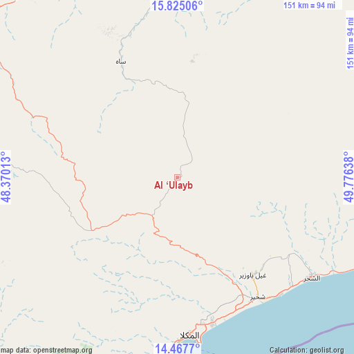
Al ‘Ulayb GPS coordinates[2]
15° 8' 50.892" North, 49° 4' 23.7" East
| Map corner | latitude | longitude |
|---|---|---|
| Upper-left | 15.82506°, | 48.37013° |
| Center: | 15.14747°, | 49.07325° |
| Lower-right: | 14.4677°, | 49.77638° |
| Map W x H: | 150.9×150.9 km | = 93.8×93.8mi |
| max Lat: | 17.76999° ⇑44.8% North |
| Al ‘Ulayb: | 15.14747° |
| min Lat: | ⇓55.2% South 12.18576° |
| min Long | Al ‘Ulayb | max Long |
| 42.67107° | 49.07325° | 54.01895° |
| W 93.5%⇐ | ⇒6.5% E |
Elevation
Elevation of Al ‘Ulayb is 1079 m = 3540 ft, and this is 225.8 m = 741 ft below average elevation for this country.
| Max E: |
2791 m = 9157 ft | 63% |
| Avg. | 1304.8 m = 4281 ft | |
| Al ‘Ulayb | 1079 m = 3540 ft | |
Min E: |
4 m = 13 ft | 37% |
See also: Yemen elevation on elevation.city.
Geographical zone
Al ‘Ulayb is located in North Torrid zone (between Equator and Tropic of Cancer). Distance of this Northern Tropic circle is 921.7 km =572.7 mi to North.| Distance of | km | miles | from Al ‘Ulayb |
|---|---|---|---|
| North Pole | 8322.8 | 5171.5 | to North |
| Arctic Circle | 5716.9 | 3552.3 | to North |
| Tropic Cancer | 921.7 | 572.7 | to North |
| Equator | 1684.2 | 1046.5 | to South |


Nearby cities:
15 places around Al ‘Ulayb: (largest is in red/bold)
• Ad Dīs ash Sharqīyah
97.7 km =60.7 mi,  105°
105°
• Al Bāţinah
78.1 km =48.5 mi,  298°
298°
• Al Ḩamdī
94.3 km =58.6 mi,  340°
340°
• Al ‘Ummāl
93.5 km =58.1 mi, 341°
• Ash Shiḩr
71.6 km =44.5 mi,  126°
126°
• At Taḩāluf
93.1 km =57.8 mi, 340°
• Ath Thawrah
93.7 km =58.2 mi, 341°
• Burūm
87.7 km =54.5 mi,  186°
186°
• Bāḩashawān
93.7 km =58.2 mi, 340°
• Ghayl Bā Wazīr
51.9 km =32.2 mi,  142°
142°
• Mukalla
67.5 km =41.9 mi,  175°
175°
• Suḩayl Shibām
97.2 km =60.4 mi,  331°
331°
• Sāh
53.4 km =33.2 mi, 333°
• Tarīm
101.4 km =63 mi,  355°
355°
• Şīf
81.9 km =50.9 mi,  283°
283°
Sources, notices
• [Note1] Compared only with cities in Yemen existing in our database
• [Src1] Map data: © OpenStreetMap contributors (CC-BY-SA)
• [Src2] Other city data from geonames.org with taken over terms of usage.
• [Src3] Geographical zone / Annual Mean Temperature by Robert A. Rohde @ Wikipedia
