Az̧ Z̧alī‘ah geodata
Az̧ Z̧alī‘ah (Ḩaḑramawt) is a seat of a second-order administrative division; located in Yemen in Asia/Aden (GMT+3) time zone. In our database, there are 51 cities with bigger population. Compared to other cities in Yemen, 52.3% of cities are located further ↓South; 88% of cities are located further ←West and 54.2% of cities have lower elevation than Az̧ Z̧alī‘ah. Note1


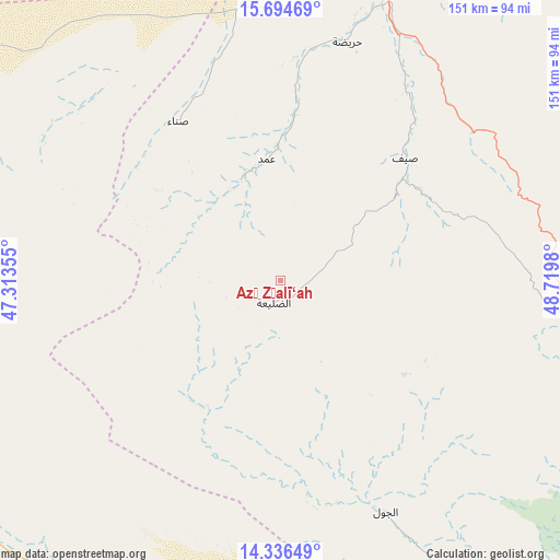
Az̧ Z̧alī‘ah GPS coordinates[2]
15° 1' 0.012" North, 48° 1' 0.012" East
| Map corner | latitude | longitude |
|---|---|---|
| Upper-left | 15.69469°, | 47.31355° |
| Center: | 15.01667°, | 48.01667° |
| Lower-right: | 14.33649°, | 48.7198° |
| Map W x H: | 151×151 km | = 93.8×93.8mi |
| max Lat: | 17.76999° ⇑47.7% North |
| Az̧ Z̧alī‘ah: | 15.01667° |
| min Lat: | ⇓52.3% South 12.18576° |
| min Long | Az̧ Z̧alī‘ | max Long |
| 42.67107° | 48.01667° | 54.01895° |
| W 88%⇐ | ⇒12% E |
Elevation
Elevation of Az̧ Z̧alī‘ah is 1398 m = 4587 ft, and this is 93.2 m = 306 ft above average elevation for this country.
| Max E: |
2791 m = 9157 ft | 45.8% |
| Az̧ Z̧alī‘ah | 1398 m 4587 ft | |
| Avg. | 1304.8 m = 4281 ft | |
Min E: |
4 m = 13 ft | 54.2% |
See also: Yemen elevation on elevation.city.
Geographical zone
Az̧ Z̧alī‘ah is located in North Torrid zone (between Equator and Tropic of Cancer). Distance of this Northern Tropic circle is 936.2 km =581.7 mi to North.| Distance of | km | miles | from Az̧ Z̧alī‘ah |
|---|---|---|---|
| North Pole | 8337.4 | 5180.6 | to North |
| Arctic Circle | 5731.5 | 3561.4 | to North |
| Tropic Cancer | 936.2 | 581.7 | to North |
| Equator | 1669.7 | 1037.5 | to South |


Nearby cities:
15 places around Az̧ Z̧alī‘ah: (largest is in red/bold)
• Al Bāţinah
68.5 km =42.6 mi,  40°
40°
• Al Jawl
68.5 km =42.6 mi,  155°
155°
• Al Māfūd
89.7 km =55.7 mi,  293°
293°
• Al Qaţan
103 km =64 mi,  27°
27°
• Al Shirūj
45.4 km =28.2 mi,  215°
215°
• Ar Rawḑah
100.3 km =62.3 mi,  232°
232°
• Aţ Ţalḩ
68.1 km =42.3 mi,  283°
283°
• Jawl al Majma‘
106.6 km =66.2 mi,  264°
264°
• Mayfa‘ah
94.7 km =58.8 mi,  209°
209°
• Maţarah
70 km =43.5 mi,  324°
324°
• Ruḑūm
107.7 km =66.9 mi,  195°
195°
• Şanā’
50.4 km =31.3 mi,  327°
327°
• Şīf
47.1 km =29.3 mi,  45°
45°
• Ḩurayḑah
67.1 km =41.7 mi,  15°
15°
• ‘Amd
31.7 km =19.7 mi,  353°
353°
Sources, notices
• [Note1] Compared only with cities in Yemen existing in our database
• [Src1] Map data: © OpenStreetMap contributors (CC-BY-SA)
• [Src2] Other city data from geonames.org with taken over terms of usage.
• [Src3] Geographical zone / Annual Mean Temperature by Robert A. Rohde @ Wikipedia
