Khimār geodata
Khimār (Shabwah) is a populated place; located in Yemen in Asia/Aden (GMT+3) time zone. With population of 3,000 people, there are 31 cities with bigger population in this country. Compared to other cities in Yemen, 65.9% of cities are located further ↑North; 82.5% of cities are located further ←West and 52.3% of cities have lower elevation than Khimār. Note1


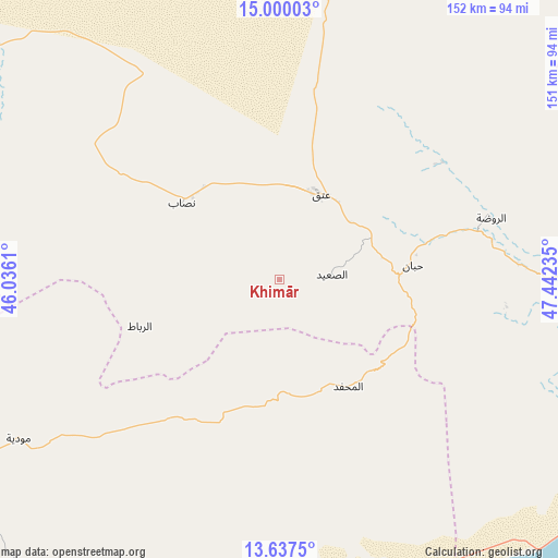
Khimār GPS coordinates[2]
14° 19' 11.28" North, 46° 44' 21.192" East
| Map corner | latitude | longitude |
|---|---|---|
| Upper-left | 15.00003°, | 46.0361° |
| Center: | 14.3198°, | 46.73922° |
| Lower-right: | 13.6375°, | 47.44235° |
| Map W x H: | 151.5×151.5 km | = 94.1×94.1mi |
| max Lat: | 17.76999° ⇑65.9% North |
| Khimār: | 14.3198° |
| min Lat: | ⇓34.1% South 12.18576° |
| min Long | Khimār | max Long |
| 42.67107° | 46.73922° | 54.01895° |
| W 82.5%⇐ | ⇒17.5% E |
Elevation
Elevation of Khimār is 1344 m = 4409 ft, and this is 39.2 m = 129 ft above average elevation for this country.
| Max E: |
2791 m = 9157 ft | 47.7% |
| Khimār | 1344 m 4409 ft | |
| Avg. | 1304.8 m = 4281 ft | |
Min E: |
4 m = 13 ft | 52.3% |
See also: Yemen elevation on elevation.city.
Geographical zone
Khimār is located in North Torrid zone (between Equator and Tropic of Cancer). Distance of this Northern Tropic circle is 1013.7 km =629.9 mi to North.| Distance of | km | miles | from Khimār |
|---|---|---|---|
| North Pole | 8414.8 | 5228.7 | to North |
| Arctic Circle | 5809 | 3609.5 | to North |
| Tropic Cancer | 1013.7 | 629.9 | to North |
| Equator | 1592.2 | 989.3 | to South |


Nearby cities:
15 places around Khimār: (largest is in red/bold)
• AL-khashā Lower
3.1 km =1.9 mi,  343°
343°
• AL-khashā upper
3.6 km =2.2 mi,  309°
309°
• Al Maḩfid
34.6 km =21.5 mi,  147°
147°
• Ar Rawḑah
60.1 km =37.3 mi,  74°
74°
• Ataq
26.2 km =16.3 mi,  22°
22°
• Aḩwar
89 km =55.3 mi,  181°
181°
• Jawl al Majma‘
74.9 km =46.5 mi, 24°
• Jayshān
60.8 km =37.8 mi,  262°
262°
• Khawrah
64.2 km =39.9 mi,  281°
281°
• Marbāţ
39.9 km =24.8 mi,  251°
251°
• Mūdīyah
83.1 km =51.6 mi,  238°
238°
• Nişāb
33.7 km =20.9 mi, 308°
• Said
14.4 km =8.9 mi,  85°
85°
• Salābah
1.6 km =1 mi, 255°
• Ḩabbān
36.5 km =22.7 mi,  84°
84°
Sources, notices
• [Note1] Compared only with cities in Yemen existing in our database
• [Src1] Map data: © OpenStreetMap contributors (CC-BY-SA)
• [Src2] Other city data from geonames.org with taken over terms of usage.
• [Src3] Geographical zone / Annual Mean Temperature by Robert A. Rohde @ Wikipedia
